Wynberg
Appearance
| Wynberg | |
|---|---|
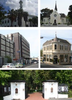
 Top left: Yusuffia Mosque in Mosque Road. Top right: Dutch Reformed Church in Wynberg. Center left: Wynberg's Apartheid era police station. Center right: Victorian building on Wolfe Street. Bottom: Maynardville Park. | |
|
Location within Cape Town Lua error in Module:Location_map at line 417: Unable to find the specified location map definition. Neither "Module:Location map/data/Cape Town" nor "Template:Location map Cape Town" exists. | |
| Coordinates: 34°00′15″S 18°28′13″E / 34.00417°S 18.47028°E | |
| Naga | Afrika Borwa |
| Porofense | Kapa Bodikela |
| Mmušôselegae | City of Cape Town Metropolitan Municipality|City of Cape Town |
| Sekgôba[1] | |
| • Total | 5.06 km2 (1.95 sq mi) |
| Setšhaba (2011)[1] | |
| • Total | 14,472 |
| • Phitlaganyo | 2,900/km2 (7,400/sq mi) |
| Nomoro ya poso (Setarata) | 7800 |
| Nomoro ya poso (Lepokisi) | 7824 |
Wynberg ke metse ya Cape Town, ka moka Afrika Borwa.
Ditšhupetšo
[lokiša | edit source]- ↑ 1.0 1.1 1.2 1.3 "Sub Place Wynberg". Census 2011.


