Skipskop
Appearance
| Skipskop | |
|---|---|
| Coordinates: 34°31′44″S 20°25′23″E / 34.529°S 20.423°E | |
| Naga | Afrika Borwa |
| Porofense | Kapa Bodikela |
| Mmasepala wa Selete | Overberg |
| Mmušôselegae | Cape Agulhas |
| Sekgôba[1] | |
| • Total | 0.96 km2 (0.37 sq mi) |
| Setšhaba (2001)[1] | |
| • Total | 55 |
| • Phitlaganyo | 57/km2 (150/sq mi) |
| Dipersente tša merafe (2001)[1] | |
| • Bammala | 38.2% |
| • Makgowa | 61.8% |
| Dipolelo tša ntlha (2001)[1] | |
| • Afrikaans | 83.6% |
| • Seisimane | 16.4% |
| Nomoro ya poso (Setarata) | Molaô la pôsô |
| Nomoro ya poso (Lepokisi) | Molaô la pôsô |
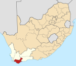
Skipskop ke toropo senyane wa Cape Agulhas, Overberg go feta Kapa Bodikela ka moka Afrika Borwa.
Village west of Arniston (Waenhuiskrans). Afrikaans for ‘ships’ cliff’, it was so named after the number of ships wrecked there.[2]
Ditšhupetšo
[lokiša | edit source]- ↑ 1.0 1.1 1.2 1.3 "Main Place Skipskop". Census 2001.
- ↑ "Dictionary of Southern African Place Names (Public Domain)". Human Science Research Council. p. 407.
Municipalities and communities of Mmasepala Setereke tša Overberg, Kapa Bodikela | ||
|---|---|---|
| District seat: Bredasdorp | ||
| Cape Agulhas | Arniston • Bredasdorp • Elim • L'Agulhas • Napier • Skipskop • Struisbaai • Suiderstrand |  |
| Overstrand | Baardskeerdersbos • Betty's Bay • Birkenhead • De Kelders • Fisherhaven • Franskraalstrand • Gansbaai • Hawston • Hermanus • Kleinbaai • Kleinmond • Onrusrivier • Pearly Beach • Pringle Bay • Rooi-Els • Sandbaai • Stanford • Van Dyks Bay • Vermont • Zwelihle | |
| Swellendam | Barrydale • Infanta • Malgas • Suurbraak • Swellendam | |
| Theewaterskloof | Botrivier • Caledon • Dennehof • Genadendal • Grabouw • Greyton • Riviersonderend • Villiersdorp | |

