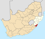
Harding, KwaZulu Natala
Appearance
| Harding | |
|---|---|
| Coordinates: 30°40′44″S 30°09′43″E / 30.679°S 30.162°E | |
| Naga | Afrika Borwa |
| Porofense | KwaZulu Natala |
| Mmasepala wa Selete | Ugu |
| Mmušôselegae | uMuziwabantu |
| Hlômile | 1874 |
| Sekgôba[1] | |
| • Total | 25.18 km2 (9.72 sq mi) |
| Setšhaba (2011)[1] | |
| • Total | 9,544 |
| • Phitlaganyo | 380/km2 (980/sq mi) |
| Dipersente tša merafe (2011)[1] | |
| • Bathobaso | 87.3% |
| • Bammala | 8.5% |
| • MaIndia | 2.3% |
| • Makgowa | 1.1% |
| • Šele | 0.8% |
| Dipolelo tša ntlha (2011)[1] | |
| • Sezulu | 49.1% |
| • Sethosa | 28.8% |
| • Seisimane | 14.6% |
| • Afrikaans | 2.8% |
| • Šele | 4.7% |
| Nomoro ya poso (Setarata) | 4680 |
| Nomoro ya poso (Lepokisi) | 4680 |
Harding ke toropo wa Mmušôgaê wa uMuziwabantu go feta Mmasepala Setereke tša Ugu ka moka Afrika Borwa.
Harding was established as a military outpost following the British annexation of East Griqualand in 1874. Named after Sir Walter Harding (1812-1874) who in 1858 became the first Chief Justice in Natal.
Timber and dairy farming are the main economic activities. The abandoned 122 km narrow gauge Alfred County Railway used to serve the farming areas, linking Harding with Port Shepstone. Harding lies at the foot of the Ingeli Range, 34 km north-west of Izingolweni and 84 km north-west of Port Shepstone.
Ditšhupetšo
[lokiša | edit source]- ↑ 1.0 1.1 1.2 1.3 "Main Place Harding". Census 2011.
Bomasepala ba le metseng ea Mmasepala Setereke tša Ugu, KwaZulu Natala | ||
|---|---|---|
| District seat: Port Shepstone | ||
| Ray Nkonyeni | Anerley • Gamalakhe • Hibberdene • Izingolweni • Mahlabathini • Marburg • Margate • Munster • Palm Beach • Port Edward • Port Shepstone • Ramsgate • Shelly Beach • Southbroom • Trafalgar • Umtentweni • Umzumbe • Uvongo • Woza |  |
| Umzumbe | Mathulini • St Faith’s | |
| uMuziwabantu | Harding • Weza | |
| Vulamehlo | Amahwaqa • Dududu • Dumisa • Emahlathini • Emgangeni • eMjunundwini • Itshehlophe • KaDlangezwa • Kenterton • KwaFakazi • KwaDumisa • Mapumulo • Mayfield • Mbulula • Mdumezulu • Mfume • Mkhumbani • Mkhunya • Mqangqala • Ncazuka • Ndaya • Nkwali • Odidini • Salaap • Ungendwa • Vonguzana • Wubwini | |
| uMdoni | Bazley • Ifafa Beach • Kelso • Mtwalume • Park Rynie • Pennington • Scottburgh • Sezela • Umzinto | |

