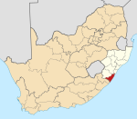
St Faith’s, KwaZulu Natala
| St Faith’s | |
|---|---|
| Coordinates: 30°31′08″S 30°12′25″E / 30.519°S 30.207°E | |
| Naga | Afrika Borwa |
| Porofense | KwaZulu Natala |
| Mmasepala wa Selete | Ugu |
| Mmušôselegae | Umzumbe |
| Government | |
| • Type | Ward 6 |
| • Councillor | Sbonakaliso Radebe (ANC) |
| Sekgôba[1] | |
| • Total | 3.10 km2 (1.20 sq mi) |
| Setšhaba (2001)[1] | |
| • Total | 794 |
| • Phitlaganyo | 260/km2 (660/sq mi) |
| Nomoro ya poso (Setarata) | Molaô la pôsô |
| Nomoro ya poso (Lepokisi) | Molaô la pôsô |
St Faith’s ke toropo wa Mmušôgaê wa Umzumbe go feta Mmasepala Setereke tša Ugu ka moka Afrika Borwa.
There are a number of settlements falling under St Faith’s: uMqangqala, Nothinwta, Dweshula, Thaleni, Ngoleleni, Zitendeni, Siqhingini, Junction, Diphini, Maromeni and Ivethe. A taxi rank in Junction serves routes to Durban, Port Shepstone, Highflats and Ixopo. The route is also used by Ugu Transport buses.
Junction is the main part of St Faith’s, it hosts a police station and health clinic near the St Faith’s Community Hall. Maria Cross, Khakhamela, St Faith’s, Impola are the primary schools, Indlelenhle Secondary and Mayiyana, Ntabalukhozi are the High Schools in St Faith’s.
Ditšhupetšo[lokiša | edit source]
- ↑ 1.0 1.1 "Census 2001 — Sub Place "St. Faith's"". Retrieved 12 September 2013.
Bomasepala ba le metseng ea Mmasepala Setereke tša Ugu, KwaZulu Natala | ||
|---|---|---|
| District seat: Port Shepstone | ||
| Ray Nkonyeni | Anerley • Gamalakhe • Hibberdene • Izingolweni • Mahlabathini • Marburg • Margate • Munster • Palm Beach • Port Edward • Port Shepstone • Ramsgate • Shelly Beach • Southbroom • Trafalgar • Umtentweni • Umzumbe • Uvongo • Woza |  |
| Umzumbe | Mathulini • St Faith’s | |
| uMuziwabantu | Harding • Weza | |
| Vulamehlo | Amahwaqa • Dududu • Dumisa • Emahlathini • Emgangeni • eMjunundwini • Itshehlophe • KaDlangezwa • Kenterton • KwaFakazi • KwaDumisa • Mapumulo • Mayfield • Mbulula • Mdumezulu • Mfume • Mkhumbani • Mkhunya • Mqangqala • Ncazuka • Ndaya • Nkwali • Odidini • Salaap • Ungendwa • Vonguzana • Wubwini | |
| uMdoni | Bazley • Ifafa Beach • Kelso • Mtwalume • Park Rynie • Pennington • Scottburgh • Sezela • Umzinto | |

