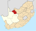
Dithakong
Appearance
| Dithakong 27°05′S 23°51′E / 27.083°S 23.850°E | |
|---|---|
 A hut in Dithakong | |
| Naga | Afrika Borwa |
| Porofense | Kapa Leboa |
| Mmasepala wa Selete | John Taolo Gaetsewe |
| Mmušôselegae | Joe Morolong |
| Sekgôba[1] | |
| • Total | 12.15 km2 (4.69 sq mi) |
| Setšhaba (2011)[1] | |
| • Total | 1,691 |
| • Phitlaganyo | 140/km2 (360/sq mi) |
| Dipersente tša merafe (2011)[1] | |
| • Bathobaso | 99.4% |
| • MaIndia | 0.3% |
| • Šele | 0.3% |
| Dipolelo tša ntlha (2011)[1] | |
| • Setswana | 96.3% |
| • Šele | 3.7% |
| Nomoro ya poso (Setarata) | Molaô la pôsô |
| Nomoro ya poso (Lepokisi) | 8604 |

1801 painting by Samuel Daniell.
Dithakong ke village botshabela ya Kuruman wa Mmušôgaê wa Joe Morolong, Mmasepala Setereke tša John Taolo Gaetsewe go feta diporofense Kapa Leboa ka moka Afrika Borwa.
Ditšhupetšo
[lokiša | edit source]- ↑ 1.0 1.1 1.2 1.3 "Main Place Dithakong". Census 2011.
Bomasepala ba le metseng ea Mmasepala Setereke tša John Taolo Gaetsewe, Kapa Leboa | ||
|---|---|---|
| District seat: Kuruman | ||
| Joe Morolong | Cassel • Dithakong • Heuningvlei • Hotazel • Van Zylsrus |  |
| Ga-Segonyana | Bankhara • Gamopedi • Ga-Ntatelang • Havard • Kuruman • Magobe • Maheane • Mamoratwe • Maruping • Mothibistad • Ntsweng • Phakane • Sedibeng • Seodin | |
| Gamagara | Dibeng • Dingleton • Kathu • Olifantshoek | |
