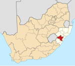
Albert Falls
Appearance
| Albert Falls | |
|---|---|
| Coordinates: 29°26′17″S 30°25′41″E / 29.438°S 30.428°E | |
| Naga | Afrika Borwa |
| Porofense | KwaZulu Natala |
| Mmasepala wa Selete | uMgungundlovu |
| Mmušôselegae | uMshwathi |
| Sekgôba[1] | |
| • Total | 7.03 km2 (2.71 sq mi) |
| Setšhaba (2011)[1] | |
| • Total | 4,536 |
| • Phitlaganyo | 650/km2 (1,700/sq mi) |
| Dipersente tša merafe (2011)[1] | |
| • Bathobaso | 96.4% |
| • Bammala | 0.2% |
| • MaIndia | 0.8% |
| • Makgowa | 2.3% |
| • Šele | 0.3% |
| Dipolelo tša ntlha (2011)[1] | |
| • Sezulu | 92.5% |
| • Seisimane | 3.9% |
| • Sesotho | 1.3% |
| • Šele | 2.4% |
| Nomoro ya poso (Setarata) | Molaô la pôsô |
| Nomoro ya poso (Lepokisi) | Molaô la pôsô |
| Khoutu ya lefelo | 031 |
Albert Falls ke toropo wa Mmasepala Setereke tša uMgungundlovu go feta porofense KwaZulu Natala ka moka Afrika Borwa.
Ditšhupetšo
[lokiša | edit source]- ↑ 1.0 1.1 1.2 1.3 "Main Place Albert Falls". Census 2011.
Bomasepala ba le metseng ea Mmasepala Setereke tša uMgungundlovu, KwaZulu Natala | ||
|---|---|---|
| District seat: Pietermaritzburg | ||
| uMshwathi | Albert Falls • Cool Air • Dalton • New Hanover • Trust Feed • Wartburg |  |
| uMngeni | Balgowan • Hilton • Howick • Lidgetton • Lions River • Merrivale • Mpophomeni • Nottingham Road | |
| Mpofana | Bruntville • Mooi River • Rosetta • Townview, Mooi River | |
| Impendle | Impendle | |
| Msunduzi | Ashburton • Edendale • Imbali • Pietermaritzburg | |
| Mkhambathini | Camperdown | |
| Richmond | Hopewell • Richmond • Thornville | |

