Pixley Ka Seme Mmusogae
Appearance
(Redirect go tšwa Pixley ka Seme Mmusogae)
| Pixley Ka Seme | |
|---|---|
| Mmušôgaê | |
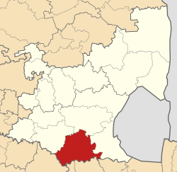
 Location in Mpumalanga | |
| Coordinates: 26°33′S 29°10′E / 26.550°S 29.167°E | |
| Naga | Afrika Borwa |
| Porofense | Mpumalanga |
| Mmasepala Setereke | Gert Sibande |
| Seat | Volksrust |
| Government[1] | |
| • Type | Municipal council |
| • Mayor | Phalaborwa Vincent Malatsi |
| Sekgôba | |
| • Total | 5,227 km2 (2,018 sq mi) |
| Setšhaba (2011)[2] | |
| • Total | 83,235 |
| • Phitlaganyo | 16/km2 (41/sq mi) |
| Racial makeup (2011)[2] | |
| • Bathobaso | 90.5% |
| • Bammala | 0.6% |
| • MaIndia | 1.2% |
| • Makgowa | 7.4% |
| Dipolelo (2011)[3] | |
| • Sezulu | 82.8% |
| • Afrikaans | 6.8% |
| • Seisimane | 2.3% |
| • Sesotho | 2.2% |
| • Other | 5.9% |
| Time zone | SAST (UTC+2) |
| Municipal code | MP304 |
Pixley Ka Seme Mmasepala ke mmusogae go feta Mmasepala Setereke tša Gert Sibande mo diporofense Mpumalanga ka moka Afrika Borwa.
Ditšhupetšo
[lokiša | edit source]- ↑ "Contact list: Executive Mayors". Government Communication & Information System. Archived from the original on 14 July 2010. Retrieved 22 February 2012.
{{cite web}}: Unknown parameter|dead-url=ignored (|url-status=suggested) (help) - ↑ 2.0 2.1 "Statistics by place". Statistics South Africa. Retrieved 27 September 2015.
- ↑ "Statistics by place". Statistics South Africa. Retrieved 27 September 2015.
