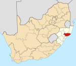
Mmušôgaê wa Nkandla
Appearance
| Mmušôgaê wa Nkandla | |
|---|---|
 Location mo KwaZulu Natala | |
| Coordinates: 28°40′S 31°0′E / 28.667°S 31.000°E | |
| Naga | Afrika Borwa |
| Porofense | KwaZulu Natala |
| Mmasepala Setereke | King Cetshwayo |
| Seat | Nkandla |
| Government[1] | |
| • Type | Municipal council |
| • Mayor | Zandile Mncandi-Mpanza |
| Sekgôba | |
| • Total | 1,828 km2 (706 sq mi) |
| Setšhaba (2011)[2] | |
| • Total | 114,416 |
| • Phitlaganyo | 63/km2 (160/sq mi) |
| Racial makeup (2011)[2] | |
| • Bathobaso | 99.6% |
| • Bammala | 0.1% |
| • MaIndia | 0.1% |
| • Makgowa | 0.1% |
| Dipolelo (2011)[3] | |
| • Sezulu | 95.7% |
| • Sendebele | 1.3% |
| • Seisimane | 1.3% |
| • Other | 1.7% |
| Time zone | SAST (UTC+2) |
| Municipal code | KZN286 |

Mmušôgaê wa Nkandla ke mmasepala go feta Mmasepala Setereke tša King Cetshwayo wa porofense KwaZulu Natala ka moka Afrika Borwa.
Toropokgolokgolo ya Mmušôgaê wa Nkandla ke Nkandla.
Ditšhupetšo
[lokiša | edit source]- ↑ "Contact list: Executive Mayors". Government Communication & Information System. Archived from the original on 14 July 2010. Retrieved 22 February 2012.
{{cite web}}: Unknown parameter|dead-url=ignored (|url-status=suggested) (help) - ↑ 2.0 2.1 "Statistics by place". Statistics South Africa. Retrieved 27 September 2015.
- ↑ "Statistics by place". Statistics South Africa. Retrieved 27 September 2015.
Bomasepala ba le metseng ea Mmasepala Setereke tša King Cetshwayo, KwaZulu Natala | ||
|---|---|---|
| District seat: Richards Bay | ||
| uMhlathuze | ESikhawini • Empangeni • Felixton • Richards Bay |  |
| uMlalazi | Amatikulu • Eshowe • Gingindlovu • Mbongolwane • Mtunzini | |
| Nkandla | Nkandla | |
| uMfolozi | Kwambonambi | |
| Ntambanana | Bhucanana | |
| Mthonjaneni | Melmoth | |
