
Mošomi:Ptpare/Lešabašaba/Crimea 2 en
Template:Other uses Template:Pp-protect Template:Use British English Template:Infobox peninsulas


Crimea[lower-alpha 1] (Template:IPAc-en Template:Respell) is a peninsula in Eastern Europe, on the northern coast of the Black Sea. It has a population of 2.4 million,[1] made up mostly of ethnic Russians, with significant Ukrainian and Crimean Tatar minorities.[2] The peninsula is almost entirely surrounded by the Black Sea and the smaller Sea of Azov. The Isthmus of Perekop connects the peninsula to Kherson Oblast in mainland Ukraine. To the east, the Crimean Bridge, constructed in 2018, spans the Strait of Kerch, linking the peninsula with Krasnodar Krai in Russia. The Arabat Spit, located to the northeast, is a narrow strip of land that separates the Sivash lagoons from the Sea of Azov. Across the Black Sea to the west lies Romania and to the south is Turkey.
Crimea (called the Tauric Peninsula until the early modern period) has historically been at the boundary between the classical world and the steppe. Greeks colonized its southern fringe and were absorbed by the Roman and Byzantine Empires and successor states while remaining culturally Greek. Some cities became trading colonies of Genoa, until conquered by the Ottoman Empire. Throughout this time the interior was occupied by a changing cast of steppe nomads. In the 14th century it became part of the Golden Horde; the Crimean Khanate emerged as a successor state. In the 15th century, the Khanate became a dependency of the Ottoman Empire. Russia was often the target of slave raids during this period. In 1783, the Russian Empire annexed Crimea after an earlier war with Turkey. Crimea's strategic position led to the 1854 Crimean War and many short lived regimes following the 1917 Russian Revolution. When the Bolsheviks secured Crimea it became an autonomous soviet republic within Russia. During World War II, Crimea was downgraded to an oblast and the Crimean Tatars were deported. The USSR transferred Crimea to Ukraine on the 300th anniversary of the Pereyaslav Treaty in 1954. After Ukrainian independence in 1991 the central government and Crimea clashed, with the region being granted more autonomy. The Soviet fleet in Crimea was also in contention but a 1997 treaty allowed Russia to continue basing its fleet in Sevastopol. In 2014 Russians seized control, organizing an illegal referendum supporting Russian annexation, but most countries recognize Crimea as Ukrainian.
Name
[lokiša | edit source]The classical name for Crimea, Tauris or Taurica, is from the Greek Ταυρική (Taurikḗ), after the peninsula's Scytho-Cimmerian inhabitants, the Tauri. Today, the Crimean Tatar name of the peninsula is Qırım, while in Russian name it is called Крым (Krym), and Крим (Krym) in Ukrainian.
Strabo (Geography vii 4.3, xi. 2.5), Polybius, (Histories 4.39.4), and Ptolemy (Geographia. II, v 9.5) refer variously to the Strait of Kerch as the Κιμμερικὸς Βόσπορος (Kimmerikos Bosporos, romanized spelling, Bosporus Cimmerius), its easternmost part as the Κιμμέριον Ἄκρον (Kimmerion Akron, Roman name: Promontorium Cimmerium),[3] as well as to the city of Cimmerium and thence the name of the Kingdom of the Cimmerian Bosporus (Κιμμερικοῦ Βοσπόρου).
The city Staryi Krym ('Old Crimea'),[4] served as a capital of the Crimean province of the Golden Horde. Between 1315 and 1329 CE, the Arab writer Abū al-Fidā recounted a political fight in 1300–1301 CE which resulted in a rival's decapitation and his head being sent "to the Crimea",[5] apparently in reference to the peninsula,[6] although some sources hold that the name of the capital was extended to the entire peninsula at some point during Ottoman suzerainty (1441–1783).[7]
The origin of the word Qırım is uncertain. Suggestions argued in various sources include:
- a corruption of Cimmerium (Greek, Kimmerikon, Κιμμερικόν).[8][9][10]
- a derivation from the Turkic term qirum ("fosse, trench"), from qori- ("to fence, protect").[11][12][13]
Other suggestions either unsupported or contradicted by sources, apparently based on similarity in sound, include:
- a derivation from the Greek Cremnoi (Κρημνοί, in post-classical Koiné Greek pronunciation, Crimni, i.e., "the Cliffs", a port on Lake Maeotis (Sea of Azov) cited by Herodotus in The Histories 4.20.1 and 4.110.2).[14] However, Herodotus identifies the port not in Crimea, but as being on the west coast of the Sea of Azov. No evidence has been identified that this name was ever in use for the peninsula.
- The Turkic term (e.g., in Template:Lang-tr) is related to the Mongolian appellation kerm "wall", but sources indicate that the Mongolian appellation of the Crimean peninsula of Qaram is phonetically incompatible with kerm/kerem and therefore deriving from another original term.[15][16][17]
The spelling "Crimea" is the Italian form, i.e., la Crimea, since at least the 17th century[18] and the "Crimean peninsula" becomes current during the 18th century, gradually replacing the classical name of Tauric Peninsula in the course of the 19th century.[19] In English usage since the early modern period the Crimean Khanate is referred to as Crim Tartary.[20]
The omission of the definite article in English ("Crimea" rather than "the Crimea") became common during the later 20th century.{{#if:citation needed
|[citation needed{{#if:
The classical name was used in 1802 in the name of the Russian Taurida Governorate.[21] While it was replaced with Krym (Template:Lang-uk; Template:Lang-ru) in the Soviet Union and has had no official status since 1921, it is still used by some institutions in Crimea, such as the Taurida National University, the Tavriya Simferopol football club, or the Tavrida federal highway.
History
[lokiša | edit source]
Ancient history
[lokiša | edit source]The recorded history of the Crimean Peninsula begins around the 5th century BC when several Greek colonies were established along its coast, the most important of which was Chersonesos near modern day Sevastopol, with Scythians and Tauri in the hinterland to the north. The Tauri gave the name the Tauric Peninsula which Crimea was called into the early modern period. The southern coast gradually consolidated into the Bosporan Kingdom which was annexed by Pontus and then became a client kingdom of Rome from 63 BC to 341 AD.
Medieval history
[lokiša | edit source]
The south coast remained Greek in culture for almost two thousand years including under Roman successor states, the Byzantine Empire (341 AD – 1204 AD), the Empire of Trebizond (1204 AD – 1461 AD), and the independent Principality of Theodoro (ended 1475 AD). In the 13th century, some Crimean port cities were controlled by the Venetians and by the Genovese, but the interior was much less stable, enduring a long series of conquests and invasions. In the medieval period, it was partially conquered by Kievan Rus' whose prince was baptized at Sevastopol starting the Christianization of Kievan Rus'.[22]
Mongol Conquest (1238–1449)
[lokiša | edit source]The north and centre of Crimea fell to the Mongol Golden Horde, although the south coast was still controlled by the Christian Principality of Theodoro and Genoese colonies. The Genoese–Mongol Wars were fought between the 13th and 15th centuries for control of south Crimea.[23]
Crimean Khanate (1443–1783)
[lokiša | edit source]In the 1440s the Crimean Khanate formed out of the collapse of the horde[24] but quite rapidly itself became subject to the Ottoman Empire, which also conquered the coastal areas which had kept independent of the Khanate. A major source of prosperity in these times were frequents raids into Russia for slaves.
Russian Empire (1783–1917)
[lokiša | edit source]Script error: No such module "Labelled list hatnote".
.jpg)
In 1774, the Ottoman Empire was defeated by Catherine the Great with the Treaty of Küçük Kaynarca making the Tatars of the Crimea politically independent. Catherine the Great's incorporation of the Crimea in 1783 into the Russian Empire increased Russia's power in the Black Sea area[25]
From 1853 to 1856, the strategic position of the peninsula in controlling the Black Sea meant that it was the site of the principal engagements of the Crimean War, where Russia lost to a French-led alliance.[26]
Russian Civil War (1917–1921)
[lokiša | edit source]During the Russian Civil War, Crimea changed hands many times and was where Wrangel's anti-Bolshevik White Army made their last stand. Many anti-Communist fighters and civilians escaped to Istanbul but up to 150,000 were killed in Crimea.
Soviet Union (1921–1991)
[lokiša | edit source]Script error: No such module "Labelled list hatnote".

In 1921 the Crimean Autonomous Soviet Socialist Republic (ASSR) was created as part of the Russian Soviet Federative Socialist Republic.[27] Crimea was occupied by Germany during the Second World War and afterwards a number of nationalities, including the Crimean Tartars, were deported to other parts of the USSR. The ASSR was dissolved in 1945, and the Crimea became an oblast which and was then transferred to the Ukrainian SSR in 1954, on the 300th anniversary of the Treaty of Pereyaslav.
Ukraine (1991–2014)
[lokiša | edit source]
With the dissolution of the Soviet Union and Ukrainian independence in 1991 most of the peninsula was reorganized as the Republic of Crimea,[28][29] although in 1995 the Republic was forcibly abolished by Ukraine with the Autonomous Republic of Crimea established firmly under Ukrainian authority.[30] A 1997 treaty partitioned the Soviet Black Sea Fleet, allowing Russia to continue basing its fleet in Sevastopol, with the lease extended in 2010.
Russian Federation (de facto; since 2014)
[lokiša | edit source]Script error: No such module "Labelled list hatnote".

Crimea's status is disputed. In 2014, Crimea saw intense demonstrations[31] against the removal of the Russia-leaning Ukrainian president Viktor Yanukovych in Kyiv. Protests culminated in pro-Russian forces occupying strategic points in Crimea[32] and the Republic of Crimea declared independence from Ukraine following an internationally disputed referendum supporting reunification.[33] Russia then formally annexed Crimea, although most countries recognize Crimea as part of Ukraine.[34]
Geography
[lokiša | edit source]Template:Location map+ Template:Further Covering an area of 27,000 km2 (10,425 sq mi), Crimea is located on the northern coast of the Black Sea and on the western coast of the Sea of Azov; the only land border is shared with Ukraine's Kherson Oblast on the north. Crimea is almost an island and only connected to the continent by the Isthmus of Perekop, a strip of land about 5–7 kilometres (3.1–4.3 mi) wide.
Much of the natural border between the Crimean Peninsula and the Ukrainian mainland comprises the Sivash or "Rotten Sea", a large system of shallow lagoons stretching along the western shore of the Sea of Azov. Besides the isthmus of Perekop, the peninsula is connected to the Kherson Oblast's Henichesk Raion by bridges over the narrow Chonhar and Henichesk straits and over Kerch Strait to the Krasnodar Krai. The northern part of Arabat Spit is administratively part of Henichesk Raion in Kherson Oblast, including its two rural communities of Shchaslyvtseve and Strilkove. The eastern tip of the Crimean peninsula comprises the Kerch Peninsula, separated from Taman Peninsula on the Russian mainland by the Kerch Strait, which connects the Black Sea with the Sea of Azov, at a width of between 3–13 kilometres (1.9–8.1 mi).
Geographers generally divide the peninsula into three zones: steppe, mountains and southern coast.
Places
[lokiša | edit source]Template:Location map+ Given its long history and many conquerors, most towns in Crimea have several names.
West: The Isthmus of Perekop /Perekop/Or Qapi, about 7 km (4 mi) wide, connects Crimea to the mainland. It was often fortified and sometimes garrisoned by the Turks. The North Crimean Canal now crosses it to bring water from the Dnieper. To the west Karkinit Bay separates the Tarkhankut Peninsula from the mainland. On the north side of the peninsula is Chernomorskoe/Kalos Limen. On the south side is the large Donuzlav Bay and the port and ancient Greek settlement of Yevpatoria/Kerkinitis/Gözleve. The coast then runs south to Sevastopol/Chersonesus, a good natural harbor, great naval base and the largest city on the peninsula. At the head of Sevastopol Bay stands Inkermann/Kalamita. South of Sevastopol is the small Heracles Peninsula.

South: In the south, between the Crimean Mountains and the sea runs a narrow coastal strip which was held by the Genoese and (after 1475) by the Turks. Under Russian rule it became a kind of riviera. In Soviet times the many palaces were replaced with dachas and health resorts. From west to east are: Heracles Peninsula; Balaklava/Symbalon/Cembalo, a smaller natural harbor south of Sevastopol; Foros, the southernmost point; Alupka with the Vorontsov Palace (Alupka); Gaspra; Yalta; Gurzuf; Alushta. Further east is Sudak/Sougdia/Soldaia with its Genoese fort. Further east still is Theodosia/Kaffa/Feodosia, once a great slave-mart and a kind of capital for the Genoese and Turks. Unlike the other southern ports, Feodosia has no mountains to its north. At the east end of the 90 km (56 mi) Kerch Peninsula is Kerch/Panticapaeum, once the capital of the Bosporian Kingdom. Just south of Kerch the new Crimean Bridge (opened in 2018) connects Crimea to the Taman Peninsula.
Sea of Azov: There is little on the south shore. The west shore is marked by the Arabat Spit. Behind it is the Syvash or "Putrid Sea", a system of lakes and marshes which in the far north extend west to the Perekop Isthmus. Road- and rail-bridges cross the northern part of Syvash.
Interior: Most of the former capitals of Crimea stood on the north side of the mountains. Mangup/Doros (Gothic, Theodoro). Bakhchisarai (1532–1783). Southeast of Bakhchisarai is the cliff-fort of Chufut-Kale/Qirq Or which was used in more warlike times. Simferopol/Ak-Mechet, the modern capital. Karasu-Bazar/Bilohorsk was a commercial center. Solkhat/Staryi Krym was the old Tatar capital. Towns on the northern steppe area are all modern, notably Dzhankoi, a major road- and rail-junction.
Rivers: The longest is the Salhyr, which rises southeast of Simferopol and flows north and northeast to the Sea of Azov. The Alma flows west to reach the Black Sea between Yevpatoria and Sevastopol. The shorter Chornaya flows west to Sevastopol Bay.
Nearby: East of the Kerch Strait the Ancient Greeks founded colonies at Phanagoria (at the head of Taman Bay), Hermonassa (later Tmutarakan and Taman), Gorgippia (later a Turkish port and now Anapa). At the northeast point of the Sea of Azov at the mouth of the Don River were Tanais, Azak/Azov and now Rostov-on-Don. North of the peninsula the Dnieper turns westward and enters the Black Sea through the east–west Dnieper-Bug Estuary which also receives the Bug River. At the mouth of the Bug stood Olvia. At the mouth of the estuary is Ochakiv. Odessa stands where the coast turns southwest. Further southwest is Tyras/Akkerman/Bilhorod-Dnistrovskyi.
Crimean Mountains
[lokiša | edit source]
The southeast coast is flanked at a distance of 8–12 kilometres (5.0–7.5 mi) from the sea by a parallel range of mountains: the Crimean Mountains.[35] These mountains are backed by secondary parallel ranges.
The main range of these mountains rises with extraordinary abruptness from the deep floor of the Black Sea to an altitude of 600–1,545 metres (1,969–5,069 ft), beginning at the southwest point of the peninsula, called Cape Fiolente. Some Greek myths state that this cape was supposedly crowned with the temple of Artemis where Iphigeneia officiated as priestess.[8] Uchan-su, on the south slope of the mountains, is the highest waterfall in Crimea.[36]
Hydrography
[lokiša | edit source]Template:Redirect-distinguish There are 257 rivers and major streams on the Crimean peninsula; they are primarily fed by rainwater, with snowmelt playing a very minor role. This makes for significant annual fluctuation in water flow, with many streams drying up completely during the summer.[37] The largest rivers are the Salhyr (Salğır, Салгир), the Kacha (Кача), the Alma (Альма), and the Belbek (Бельбек). Also important are the Kokozka (Kökköz or Коккозка), the Indole (Indol or Индо́л), the Chorna (Çorğun, Chernaya or Чёрная), the Derekoika (Dereköy or Дерекойка),[38] the Karasu-Bashi (Biyuk-Karasu or Биюк-Карасу) (a tributary of the Salhyr river), the Burulcha (Бурульча) (also a tributary of the Salhyr), the Uchan-su, and the Ulu-Uzen'. The longest river of Crimea is the Salhyr at 204 km (127 mi). The Belbek has the greatest average discharge at 2.16 cubic metres per second (76 cu ft/s).[39] The Alma and the Kacha are the second- and third-longest rivers.[40]

There are more than fifty salt lakes and salt pans on the peninsula. The largest of them is Lake Sasyk (Сасык) on the southwest coast; others include Aqtas, Koyashskoye, Kiyatskoe, Kirleutskoe, Kizil-Yar, Bakalskoe, and Donuzlav.[42] The general trend is for the former lakes to become salt pans.[43] Lake Syvash (Sıvaş or Сива́ш) is a system of interconnected shallow lagoons on the north-eastern coast, covering an area of around 2,560 km2 (988 sq mi). A number of dams have created reservoirs; among the largest are the Simferopolskoye, Alminskoye,[44] the Taygansky and the Belogorsky just south of Bilohirsk in Bilohirsk Raion.[45] The North Crimea Canal, which transports water from the Dnieper, is the largest of the man-made irrigation channels on the peninsula.[46]
Crimea is facing an unprecedented water shortage crisis.[47][48]
Steppe
[lokiša | edit source]Seventy-five percent of the remaining area of Crimea consists of semiarid prairie lands, a southward continuation of the Pontic–Caspian steppe, which slope gently to the northwest from the foothills of the Crimean Mountains. Numerous kurgans, or burial mounds, of the ancient Scythians are scattered across the Crimean steppes.
Crimean Riviera
[lokiša | edit source]
The terrain that lies south of the sheltering Crimean Mountain range is of an altogether different character. Here, the narrow strip of coast and the slopes of the mountains are smothered with greenery. This "riviera" stretches along the southeast coast from capes Fiolente and Aya, in the south, to Feodosia. It is studded with summer sea-bathing resorts such as Alupka, Yalta, Gurzuf, Alushta, Sudak, and Feodosia. During the years of Soviet rule, the resorts and dachas of this coast served as prime perquisites of the politically loyal.{{#if:citation needed
|[citation needed{{#if: In addition, vineyards and fruit orchards are located in the region. Fishing, mining, and the production of essential oils are also important. Numerous Crimean Tatar villages, mosques, monasteries, and palaces of the Russian imperial family and nobles are found here, as well as picturesque ancient Greek and medieval castles.
The Crimean Mountains and the southern coast are part of the Crimean Submediterranean forest complex ecoregion. The natural vegetation consists of scrublands, woodlands, and forests, with a climate and vegetation similar to the Mediterranean Basin.
Climate
[lokiša | edit source]
Crimea is located between the temperate and subtropical climate belts and is characterized by warm and sunny weather.[49] It is characterized by diversity and the presence of microclimates.[49] The northern parts of Crimea have a moderate continental climate with short but cold winters and moderately hot dry summers.[50] In the central and mountainous areas the climate is transitional between the continental climate to the north and the Mediterranean climate to the south.[50] Winters are mild at lower altitudes (in the foothills) and colder at higher altitudes.[50] Summers are hot at lower altitudes and warm in the mountains.[50] A subtropical, Mediterranean climate dominates the southern coastal regions, is characterized by mild winters and moderately hot, dry summers.[50]
The climate of Crimea is influenced by its geographic location, relief, and influences from the Black sea.[49] The Crimean coast is shielded from cold air masses coming from the north and, as a result, has milder winters.[49] Maritime influences from the Black Sea are restricted to coastal areas; in the interior of the peninsula the maritime influence is weak and does not play an important role.[49] Because a high-pressure system is located north of Crimea in both summer and winter, winds predominantly come from the north and northeast year-round.[49] In winter these winds bring in cold, dry continental air, while in summer they bring in dry and hot weather.[49] Winds from the northwest bring warm and wet air from the Atlantic Ocean, causing precipitation during spring and summer.[49] As well, winds from the southwest bring very warm and wet air from the subtropical latitudes of the Atlantic Ocean and the Mediterranean sea and cause precipitation during fall and winter.[49]
Mean annual temperatures range from 10 °C (50.0 °F) in the far north (Armiansk) to 13 °C (55.4 °F) in the far south (Yalta).[49] In the mountains, the mean annual temperature is around 5.7 °C (42.3 °F).[49] For every 100 m (330 ft) increase in altitude, temperatures decrease by 0.65 °C (1.17 °F) while precipitation increases.[49] In January mean temperatures range from −3 °C (26.6 °F) in Armiansk to 4.4 °C (39.9 °F) in Myskhor.[49] Cool-season temperatures average around 7 °C (44.6 °F) and it is rare for the weather to drop below freezing except in the mountains, where there is usually snow.[51] In July mean temperatures range from 15.4 °C (59.7 °F) in Ai-Petri to 23.4 °C (74.1 °F) in the central parts of Crimea to 24.4 °C (75.9 °F) in Myskhor.[49] The frost-free period ranges from 160 to 200 days in the steppe and mountain regions to 240–260 days on the south coast.[49]
Precipitation in Crimea varies significantly based on location; it ranges from 310 millimetres (12.2 in) in Chornomorske to 1,220 millimetres (48.0 in) at the highest altitudes in the Crimean mountains.[49] The Crimean mountains greatly influence the amount of precipitation present in the peninsula.[49] However, most of Crimea (88.5%) receives 300 to 500 millimetres (11.8 to 19.7 in) of precipitation per year.[49] The plains usually receive 300 to 400 millimetres (11.8 to 15.7 in) of precipitation per year, increasing to 560 millimetres (22.0 in) in the southern coast at sea level.[49] The western parts of the Crimean mountains receive more than 1,000 millimetres (39.4 in) of precipitation per year.[49] Snowfall is common in the mountains during winter.[50]
Most of the peninsula receives more than 2,000 sunshine hours per year; it reaches up to 2,505 sunshine hours in Karabi–Yayla in the Crimean mountains.[49] As a result, the climate favors recreation and tourism.[49] Because of its climate and subsidized travel-packages from Russian state-run companies, the southern Crimean coast has remained a popular resort for Russian tourists.[52]
Strategic value
[lokiša | edit source]
The Black Sea ports of Crimea provide quick access to the Eastern Mediterranean, Balkans and Middle East. Historically, possession of the southern coast of Crimea was sought after by most empires of the greater region since antiquity (Roman, Byzantine, Ottoman, Russian, British and French, Nazi German, Soviet).[53]
The nearby Dnieper River is a major waterway and transportation route that crosses the European continent from north to south and ultimately links the Black Sea with the Baltic Sea, of strategic importance since the historical trade route from the Varangians to the Greeks. The Black Sea serves as an economic thoroughfare connecting the Caucasus region and the Caspian Sea to central and Eastern Europe.[54]
According to the International Transport Workers' Federation, as of 2013[update] there were at least 12 operating merchant seaports in Crimea.[55]
Economy
[lokiša | edit source]Script error: No such module "Labelled list hatnote".

In 2016 Crimea had Nominal GDP of US$7 billion and US$3,000 per capita.[56]
The main branches of the modern Crimean economy are agriculture and fishing oysters pearls, industry and manufacturing, tourism, and ports. Industrial plants are situated for the most part in the southern coast (Yevpatoria, Sevastopol, Feodosia, Kerch) regions of the republic, few northern (Armiansk, Krasnoperekopsk, Dzhankoi), aside from the central area, mainly Simferopol okrug and eastern region in Nizhnegorsk (few plants, same for Dzhankoj) city. Important industrial cities include Dzhankoi, housing a major railway connection, Krasnoperekopsk and Armiansk, among others.
After the Russian annexation of Crimea in early 2014 and subsequent sanctions targeting Crimea, the tourist industry suffered major losses for two years. The flow of holidaymakers dropped 35 percent in the first half of 2014 over the same period of 2013.[57] The number of tourist arrivals reached a record in 2012 at 6.1 million.[58] According to the Russian administration of Crimea, they dropped to 3.8 million in 2014,[59] and rebounded to 5.6 million by 2016.[60]
The most important industries in Crimea include food production, chemical fields, mechanical engineering, and metalworking, and fuel production industries.[61] Sixty percent of the industry market belongs to food production. There are a total of 291 large industrial enterprises and 1002 small business enterprises.[61]
In 2014, the republic's annual GDP was $4.3 billion (500 times smaller than the size of Russia's economy). The average salary was $290 per month. The budget deficit was $1.5 billion.[62]
Agriculture
[lokiša | edit source]Agriculture in the region includes cereals, vegetable-growing, gardening, and wine-making, particularly in the Yalta and Massandra regions. Livestock production includes cattle breeding, poultry keeping, and sheep breeding.[61] Other products produced on the Crimean Peninsula include salt, porphyry, limestone, and ironstone (found around Kerch) since ancient times.[8]
The vine mealybug (Planococcus ficus) was first discovered here in 1868. First discovered on grape, it has also been found as a pest of some other crops and has since spread worldwide.[63] Sunn pests—especially Eurygaster integriceps[64] and E. maura[65]—are significant grain pests.[64] Scelioninae and Tachinidae are important parasitoids of sunnpest.[64] Bark beetles are pests of tree crops, and are themselves hosts for Elattoma mites and various entomopathogenic fungi transmitted by those Elattomae.[66][67]
Energy
[lokiša | edit source]Crimea also possesses several natural gas fields both onshore and offshore, which were starting to be drilled by western oil and gas companies before annexation.[68][69] The inland fields are located in Chornomorske and Dzhankoi, while offshore fields are located in the western coast in the Black Sea and in the northeastern coast in the Azov Sea:[70]
| Name | Type | Location | Reserves |
|---|---|---|---|
| Dzhankoi gas field | onshore | Dzhankoi | |
| Holitsynske gas field | offshore | Black Sea | |
| Karlavske gas field | onshore | Chornomorske | |
| Krym gas field | offshore | Black Sea | |
| Odessa gas field[71] | offshore | Black Sea | 21 billion m3 |
| Schmidta gas field | offshore | Black Sea | |
| Shtormvaia gas field | offshore | Black Sea | |
| Strilkove gas field | offshore | Sea of Azov |
The republic also possesses two oil fields: one onshore, the Serebryankse oil field in Rozdolne, and one offshore, the Subbotina oil field in the Black Sea.
- Electricity
Crimea has 540 MW of its own electricity generation capacity, including the 100 MW Simferopol Thermal Power Plant, the 22 MW Sevastopol Thermal Power Plant and the 19 MW Kamish-Burunskaya Thermal Power Plant.[72] This local electricity generation has proven insufficient for local consumption and since annexation by Russia, Crimea has been reliant on an underwater power cable to mainland Russia.[73]
This power production is set to be bolstered by the building of and near start up of two combined cycle gas steam turbo thermal plants PGU, both providing 470 MW (116 167 MW GT, 235 MW block), a build (plant) by TPE along others with turbines provided by Power Machines (UTZ KalugaTZ ?), NPO Saturn with Perm PMZ; either GTD-110M modified or GTE-160 or 180 units or UTZ KTZ or a V94.2 bought by MAPNA, modified in Russian plants for PGU Thermal plants specifics.
Also many solar photovoltaic SES plants lie along the peninsula, in addition to a smaller facility north of Sevastopol. There also is the gas thermal Saky plant located close to Jodobrom chemical plant and SaKhZ(SaChP) boosted production with Perm GTE GTU25P (PS90GP25 25 MW aeroderivative GP) PGU turbogenerators. Older plants in operation include the Sevastopol TEC (close to Inkerman) which uses AEG and Ganz Elektro turbines and turbogenerators generating about 25 MW each, Sinferopol TEC (north, in Agrarne locale) Yepvatoria, Kamysh Burun TEC (Kerch south – Zaliv) and a few others.
Transport
[lokiša | edit source]- Crimean Bridge


In May 2015, work began on a multibillion-dollar road-rail link (a pair of parallel bridges) across the Kerch Strait.[74] The road bridge opened in May 2018, and the rail bridge opened in December 2019.[lower-alpha 2] With a length of 19 km, it is the longest bridge in Europe, as it overcame Vasco da Gama Bridge in Lisbon. This bridge was damaged during an attack on October 8, 2022.
- Public transportation
Almost every settlement in Crimea is connected with another settlement by bus lines. Crimea contains the longest (96 km or 59 mi) trolleybus route in the world, founded in 1959, stretching from Simferopol to Yalta.[76] The trolleybus line starts near Simferopol's Railway Station (in Soviet times it started near Simferopol International Airport) through the mountains to Alushta and on to Yalta. The length of line is about 90 km and passengers are assigned a seat. Simferopol, Yalta and Alushta also have an urban and suburban trolleybus network. Trolleybuses are also operated in Sevastopol and Kerch
In the city of Yevpatoria a tram system is also operated. In the nearby townlet village of Molochnoye, a 1.6 km-long tram line provides the only connection between the sea shore and a holiday resort, but its operation is halted since 2015.
- Railway traffic
There are two railroad lines running through Crimea: the non-electrified Armiansk—Kerch (with a link to Feodosia), and the electrified Melitopol—Simferopol-Sevastopol (with a link to Yevpatoria), connecting Crimea to the Ukrainian mainland.
Until 2014 the network was part of the Cisdneper Directorate of the Ukrainian Railways. Long-distance trains provided connection to every major Ukrainian cities, but also to many towns of Russia, Belarus and until the end of the 2000es even to Vilnius, Riga, Warsaw and Berlin.
Since 2014 the railways are operated by the Crimea Railway. Local trains belong to the Yuzhnaya Prigorodnaya Passazhirskaya Kompaniya (Southern Suburban Passenger Company), serving the entire network of the peninsula and via the Crimean Bridge three trains daily to Anapa. Long-distance trains under the name Tavriya – operated by the company Grand Servis Ekspress – connect Sevastopol and Simferopol daily with Moscow and Saint Petersburg, in the summer season Yevpatoria and Feodosia are also directly connected by them. Several times a week Simferopol is also linked with Volgograd, Sochi, Yekaterinburg, Omsk and even Murmansk by train.
Further development plans consist a bypass line between Simferopol and Kerch, and a complete electrification of the network with changing the voltage of the already electrified lines from 3 kV DC to 25 kV 50 Hz AC.
- International airport
- Simferopol International Airport's new terminal opened in from April 2018 with the ability to handle 6.5 million passengers a year.[77] It was built in 22 months and covers an area of 78,000 square meters.[78]
- Highways
- (under construction) Tavrida highway (route Yevpatoria-) Sevastopol – Simferopol (SW to W N to East ring) – Bilohirsk
– north Feodosia – Kerch south (strait bridge) - E105/M18 – Syvash (bridge, starts), Dzhankoi, North Crimean Canal (bridge), Simferopol, Alushta, Yalta (ends)
- E97/M17 – Perekop (starts), Armiansk, Dzhankoi, Feodosia, Kerch (ferry, ends)
- A290 – Novorossiysk to Kerch via the Crimean Bridge (formerly known as Highway M25)
- H05 – Krasnoperekopsk, Simferopol (access to the Simferopol International Airport)
- H06 – Simferopol, Bakhchysarai, Sevastopol
- H19 – Yalta, Sevastopol
- P16
- P23 – Simferopol, Feodosia
- P25 – Simferopol, Yevpatoria
- P27 – Sevastopol, Inkerman (completely within the city of Sevastopol)
- P29 – Alushta, Sudak, Feodosia
- P34 – Alushta, Yalta
- P35 – Hrushivka, Sudak
- P58 – Sevastopol, Port "Komysheva Bukhta" (completely within the city of Sevastopol)
- P59 (completely within the city of Sevastopol)
- Sea transport
The cities of Yalta, Feodosia, Kerch, Sevastopol, Chornomorske and Yevpatoria are connected to one another by sea routes.
Tourism
[lokiša | edit source]
.JPG)

The development of Crimea as a holiday destination began in the second half of the 19th century. The development of the transport networks brought masses of tourists from central parts of the Russian Empire. At the beginning of the 20th century, a major development of palaces, villas, and dachas began—most of which remain. These are some of the main attractions of Crimea as a tourist destination. There are many Crimean legends about famous touristic places, which attract the attention of tourists.
A new phase of tourist development began when the Soviet government started promoting the healing quality of the local air, lakes and therapeutic muds. It became a "health" destination for Soviet workers, and hundreds of thousands of Soviet tourists visited Crimea.
Artek is a former Young Pioneer camp on the Black Sea in the town of Hurzuf, near Ayu-Dag, established in 1925.[79][80] By 1969 it had an area of 3.2 km2 (1.2 sq mi), and consisted of 150 buildings. Unlike most of the young pioneer camps, Artek was an all-year camp, due to the warm climate. Artek was considered to be a privilege for Soviet children during its existence, as well as for children from other communist countries. During its heyday, 27,000 children a year vacationed at Artek. Between 1925 and 1969 the camp hosted 300,000 children.[81] After the breaking up of the Young Pioneers in 1991 its prestige declined, though it remained a popular vacation destination.[80]
In the 1990s, Crimea became more of a get-away destination than a "health-improvement" destination. The most visited areas are the south shore of Crimea with cities of Yalta and Alushta, the western shore – Yevpatoria and Saky, and the south-eastern shore – Feodosia and Sudak. According to National Geographic, Crimea was among the top 20 travel destinations in 2013.[82]
Places of interest include Template:Col-list
Sanctions
[lokiša | edit source]Following Russia's largely unrecognized annexation of Crimea, the European Union, the United States, Canada, Australia, Japan, and several other countries (including Ukraine) imposed economic sanctions against Russia, including some specifically targeting Crimea. Many of these sanctions were directed at individuals—both Russian and Crimean.[83][84] In general they prohibit the sale, supply, transfer, or export of goods and technology in several sectors, including services directly related to tourism and infrastructure. They list seven ports where cruise ships cannot dock.[85][86][87][88] Sanctions against individuals include travel bans and asset freezes. Visa and MasterCard temporarily stopped service in Crimea in December 2014.[89][90] The Russian national payment card system now allows Visa and MasterCard cards issued by Russian banks to work in Crimea.{{#if:citation needed
|[citation needed{{#if: The Mir payment system operated by the Central Bank of Russia operates in Crimea as well as Master Card and Visa.{{#if:citation needed
|[citation needed{{#if: However, there are no major international banks in the Crimea.[91]
Politics
[lokiša | edit source]Script error: No such module "Labelled list hatnote". Script error: No such module "Labelled list hatnote".

Crimea is contested territory; Ukraine has not relinquished title over the Crimean territory since the events of 2014, and still exercises de jure rights. They exercise in extremis administration of the Autonomous Republic of Crimea from Kyiv in the Ministry of Reintegration of Temporarily Occupied Territories. Ukrainian president Zelenskiy drew attention to this fact in August 2022 when he stated that it was "necessary to liberate Crimea" from Russian occupation and to re-establish "world law and order",[92] after he said "Russians are realising Crimea is not a place for them."[93]
Crimea is divided into the Republic of Crimea and the city of Sevastopol. Since becoming the 84th and 85th federal subjects of the Russian Federation in 2014,[94] voters in both have strongly supported United Russia in local and national elections. At the most recent Crimean parliamentary election on 14 September 2014, United Russia won 70 of the 75 seats in the State Council of Crimea based on just over 70% of the vote. Despite calls from local Crimean Tatars for a boycott of the elections, turnout was over 53%, which compared well with elections in other regions of Russia. Following the election, Sergey Aksyonov became Head of the Republic of Crimea: he had previously been Acting HeadTemplate:Clarify since 14 April 2014. United Russia is also the leading party in the Legislative Assembly of Sevastopol, having won 22 of the 24 seats at the last election.[95] The governor of Sevastopol is Dmitry Ovsyannikov who was first appointed on 28 July 2016 following the resignation of Sergey Menyaylo, and secured re-election on 71% of the vote on 10 September 2017.
United Russia maintained its position as the most supported political party across Crimea at the Russian legislative election on 18 September 2016, achieving 72.8% of the vote. At 49.1%, turnout was slightly ahead of that for Russia as a whole which was only 47.8%.[96]
In the 2018 Russian presidential election, Vladimir Putin secured 92% of the vote in Crimea compared to 77% across Russia as a whole.[97]
A 2019 survey with a response rate of 54% indicated a majority of Crimean residents support Russian governance, with approval for the 2014 referendum outcome at 84% among Russians, 77% among Ukrainians, and 52% among Tatars.[98]
Demographics
[lokiša | edit source]As of 2014[update], the total population of the Republic of Crimea and Sevastopol was 2,248,400 people (Republic of Crimea: 1,889,485, Sevastopol: 395,000).[99] This is down from the 2001 Ukrainian Census figure, which was 2,376,000 (Autonomous Republic of Crimea: 2,033,700, Sevastopol: 342,451).[100]

According to the 2014 Russian census, 84% of Crimean inhabitants named Russian as their native language; 7.9% – Crimean Tatar; 3.7% – Tatar; and 3.3% – Ukrainian.{{#if:citation needed
|[citation needed{{#if: It was the first official census in Crimea since a Ukrainian-held census in 2001.[101]
According to the 2001 census, 77% of Crimean inhabitants named Russian as their native language; 11.4% – Crimean Tatar; and 10.1% – Ukrainian.[102] In 2013, however, the Crimean Tatar language was estimated to be on the brink of extinction, being taught in Crimea only in around 15 schools at that point. Turkey provided the greatest support to Tatars in Ukraine, which had been unable to resolve the problem of education in their mother tongue in Crimea, by bringing the schools to a modern state.[103][104]
Ethnic composition of Crimea's population has changed dramatically since the early 20th century. The 1897 Russian Empire Census for the Taurida Governorate reported: 196,854 (13.06%) Crimean Tatars, 404,463 (27.94%) Russians and 611,121 (42.21%) Ukrainians. But these numbers included Berdyansky, Dneprovsky and Melitopolsky uyezds which were on mainland, not in Crimea. The population number excluding these uyezds is given in the table below.
| Date | 1785 [105] | 1795 [105] | 1816 [105] | 1835 [105] | 1850 [105] | 1864 [105] | 1897[106][107] | 1926[108] | 1939[109] | 1959[110] | 1970 | 1979[111] | 1989[112][113] | 2001[113] | 2014[114] | |||||||||
|---|---|---|---|---|---|---|---|---|---|---|---|---|---|---|---|---|---|---|---|---|---|---|---|---|
| Carried out by | Russian Empire | Soviet Union | Ukraine | Russia | ||||||||||||||||||||
| Ethnic group | % | % | % | % | % | % | Number | % | Number | % | Number | % | Number | % | Number | % | Number | % | Number | % | Number | % | Number | % |
| Russians | 2.2% | 4.3% | 4.8% | 4.4% | 6.6% | 28.5% | 180,963 | 33.11% | 301,398 | 42.2% | 558,481 | 49.6% | 858,273 | 71.4% | 1,220,484 | 67.3% | 1,460,980 | 66.9% | 1,629,542 | 67.0% | 1,450,400 | 60.4% | 1,492,078 | 67.9% |
| Ukrainians | 1.3% | 3.6% | 3.1% | 7% | 64,703 | 11.84% | 77,405 | 10.6% | 154,123 | 13.7% | 267,659 | 22.3% | 480,733 | 26.5% | 547,336 | 25.1% | 625,919 | 25.8% | 576,600 | 24.0% | 344,515 | 15.7% | ||
| Crimean Tatars | 84.1% | 87.6% | 85.9% | 83.5% | 77.8% | 50.3% | 194,294 | 35.55% | 179,094 | 25.1% | 218,879 | 19.4% | 5,422 | 0.2% | 38,365 | 1.6% | 245,200 | 10.2% | 232,340 | 10.6% | ||||
| Belarusians | 2,058 | 0.38% | 3,842 | 0.5% | 6,726 | 0.6% | 21,672 | 1.8% | 39,793 | 2.2% | 45,000 (e) | 2.1% | 50,045 | 2.1% | 35,000 | 1.5% | 21,694 | 1.0% | ||||||
| Armenians | .6% | 1.3% | 1.5% | 1% | 6.5% | 8,317 | 1.52% | 10,713 | 1.5% | 12,923 | 1.1% | 3,091 | 0.2% | 2,794 | 0.1% | 10,000 | 0.4% | 11,030 | 0.5% | |||||
| Jews | 2.3% | 2.3% | 2% | 2.2% | 7% | 24,168 | 4.42% | 45,926 | 6.4% | 65,452 | 5.8% | 26,374 | 2.2% | 25,614 | 1.4% | 17,371 | 0.7% | 5,500 | 0.2% | 3,374 | 0.1% | |||
| Others | 13.7% | 3.9% | 2.1% | 5.5% | 5.4% | 7.7% | 72,089 | 13.19% | c.27,500 | 2.3% | 92,533 | 4.2% | ||||||||||||
| Total population stating nationality | 546,592 | 713,823 | 1,126,429 | 1,813,502 | 2,184,000 | 2,430,495 | 2,401,200 | 2,197,564 | ||||||||||||||||
| Nationality not stated | 12,000 | 87,205 | ||||||||||||||||||||||
| Total population | 1,201,517 | 2,458,600 | 2,413,200 | 2,284,769 | ||||||||||||||||||||
Crimean Tatars, a predominantly Muslim ethnic minority who in 2001 made up 12.1% of the population,[115] formed in Crimea in the early modern era, after the Crimean Khanate had come into existence. The Crimean Tatars were forcibly expelled to Central Asia by Joseph Stalin's government as a form of collective punishment, on the grounds that some had joined the invading Waffen-SS, forming Tatar Legions, during World War II. After the fall of the Soviet Union, Crimean Tatars began to return to the region.[116] According to the 2001 Ukrainian population census, 60% of the population of Crimea are ethnic Russians and 24% are ethnic Ukrainians.[115]
Jews in Crimea were historically Krymchaks and Karaites (the latter a small group centered at Yevpatoria). The 1879 census for the Taurida Governorate reported a Jewish population of 4.20%, not including a Karaite population of 0.43%. The Krymchaks (but not the Karaites) were targeted for annihilation during Nazi occupation.
The number of Crimea Germans was 60,000 in 1939. During WWII, they were forcibly deported on the orders of Stalin, as they were regarded as a potential "fifth column".[117][118][119] This was part of the 800,000 Germans in Russia who were relocated within the Soviet Union during Stalinist times.[120] The 2001 Ukrainian census reports just 2,500 ethnic Germans (0.1% of population) in Crimea.
Besides the Crimean Germans, Stalin in 1944 also deported 70,000 Greeks, 14,000 Bulgarians[121] and 3,000 Italians.
- Life expectancy at birth
-
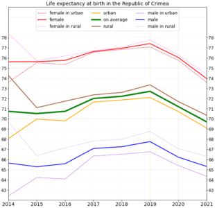 Life expectancy in Template:Nobr
 -
 Life expectancy in Sevastopol
 -
 Life expectancy in Crimea and neighboring regions


- Religion
Template:Pie chart In 2013, Orthodox Christians made up 58% of the Crimean population, followed by Muslims (15%) and believers in God without religion (10%).[122]
Following the 2014 Russian annexation of Crimea, 38 out of the 46 Ukrainian Orthodox Church – Kyiv Patriarchate parishes in Crimea ceased to exist; in three cases, churches were seized by the Russian authorities.[123] Notwithstanding the annexation, the Ukrainian Orthodox Church (Moscow Patriarchate) kept control of its eparchies in Crimea.[124]
Culture
[lokiša | edit source]Script error: No such module "Labelled list hatnote".

Alexander Pushkin visited Bakhchysarai in 1820 and later wrote the poem The Fountain of Bakhchisaray. Crimea was the background for Adam Mickiewicz's seminal work, The Crimean Sonnets inspired by his 1825 travel. A series of 18 sonnets constitute an artistic telling of a journey to and through the Crimea, they feature romantic descriptions of the oriental nature and culture of the East which show the despair of an exile longing for the homeland, driven from his home by a violent enemy.
Ivan Aivazovsky, the 19th-century marine painter of Armenian origin, who is considered one of the major artists of his era was born in Feodosia and lived there for the most part of his life. Many of his paintings depict the Black Sea. He also created battle paintings during the Crimean War.[125]
Crimean Tatar singer Jamala won the Eurovision Song Contest 2016 representing Ukraine with her song "1944", about the historic deportation of Crimean Tatars in that year by Soviet authorities.[126]
-
 Painting of the Russian squadron in Sevastopol by Ivan Aivazovsky (1846)
 -
 The grave of Russian poet and artist Maximilian Voloshin
 -
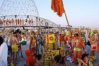 People at the Kazantip music festival in 2007


Sport
[lokiša | edit source]Following Crimea's vote to join Russia and subsequent annexation in March 2014, the top football clubs withdrew from the Ukrainian leagues. Some clubs registered to join the Russian leagues but the Football Federation of Ukraine objected. UEFA ruled that Crimean clubs could not join the Russian leagues but should instead be part of a Crimean league system. The Crimean Premier League is now the top professional football league in Crimea.[127]
A number of Crimean-born athletes have been given permission to compete for Russia instead of Ukraine at future competitions, including Vera Rebrik, the European javelin champion.[128] Due to Russia currently being suspended from all international athletic competitions Rebrik participates in tournaments as a "neutral" athlete.[129]
Gallery
[lokiša | edit source]-

-

-

-

-
 Catholic church in Yalta
 -
 St. Vladimir's Cathedral, dedicated to the Heroes of Sevastopol (Crimean War).


See also
[lokiša | edit source]- 2014 Russian military intervention in Ukraine
- Crimean Gothic
- List of cities in Crimea
- Politics of Crimea
- Russian–Ukrainian Friendship Treaty of 1997
- International recognition of the Donetsk People's Republic and the Luhansk People's Republic
Notes
[lokiša | edit source]Explanatory notes
[lokiša | edit source]Citations
[lokiša | edit source]- ↑ Cite error: Invalid
<ref>tag; no text was provided for refs namedpop - ↑ Cite error: Invalid
<ref>tag; no text was provided for refs namedkry - ↑ Compiled from original authors (1779). "The History of the Bosporus". An Universal History,rom the Earliest Accounts to the Present Time. pp. 127–129.
- ↑ William Smith, Dictionary of Greek and Roman Geography (1854), s.v. Taurica Chersonesus. vol. ii, p. 1109.
- ↑ Abū al-Fidā, Mukhtaṣar tāʾrīkh al-bashar ("A Brief History of Mankind"), 1315–1329; English translation of chronicle contemporaneous with Abū al-Fidā in The Memoirs of a Syrian Prince : Abul̓-Fidā,̕ sultan of Ḥamāh (672-732/1273-1331) by Peter M. Holt, Franz Steiner Verlag, 1983, pp. 38–39.
- ↑ Edward Allworth, The Tatars of Crimea: Return to the Homeland: Studies and Documents, Duke University Press, 1998, p.6
- ↑ W. Radloff, Versuch eines Wörterbuches der Türk-Dialecte (1888), ii. 745
- ↑ 8.0 8.1 8.2 Kropotkin, Peter Alexeivitch; Bealby, John Thomas (1911). . In Chisholm, Hugh (ed.). Encyclopædia Britannica (in English). Vol. 07 (11th ed.). Cambridge University Press. pp. 449–450, see line one.
...ancient Tauris or Tauric Chersonese, called by the Russians by the Tatar name Krym or Crim
- ↑ Alexander MacBean; Samuel Johnson (1773). A Dictionary of Ancient Geography: Explaining the Local Appellations in Sacred, Grecian, and Roman History; Exhibiting the Extent of Kingdoms, and Situations of Cities, &c. And Illustrating the Allusions and Epithets in the Greek and Roman Poets. The Whole Established by Proper Authorities, and Designed for the Use of Schools. G. Robinson. p. 185.
- ↑ Asimov, Isaac (1991). Asimov's Chronology of the World. New York: HarperCollins. p. 50. ISBN 9780062700360..
- ↑ George Vernadsky, Michael Karpovich, A History of Russia, Yale University Press, 1952, p. 53. Quote:
- "The name Crimea is to be derived from the Turkish word qirim (hence the Russian krym), which means "fosse" and refers more specifically to the Perekop Isthmus, the old Russian word perekop being an exact translation of the Turkish qirim.
- ↑ The Proto-Turkic root is cited as *kōrɨ- "to fence, protect" Starling (citing Севортян Э. В. и др. [E. W. Sewortyan et al.], Этимологический словарь тюркских языков [An Etymological Dictionary of the Turkic languages] (1974–2000) 6, 76–78).
- ↑ Edward Allworth, The Tatars of Crimea: Return to the Homeland : Studies and Documents, Duke University Press, 1998, pp. 5–7
- ↑ A. D. (Alfred Denis) Godley. Herodotus. Cambridge. Harvard University Press. vol. 2, 1921, p. 221.
- ↑ See John Richard Krueger, specialist in the studies of Chuvash, Yakut, and the Mongolian languages in Edward Allworth, The Tatars of Crimea: Return to the Homeland : Studies and Documents, Duke University Press, 1998, p. 24.
- ↑ Jews in Byzantium: Dialectics of Minority and Majority Cultures, BRILL, 2011, p.753, n. 102.
- ↑ The Mongolian kori− is explained as a loan from Turkic by Doerfer Türkische und mongolische Elemente im Neupersischen 3 (1967), 450 and by Щербак, Ранние тюркско-монгольские языковые связи (VIII-XIV вв.) (1997) p. 141.
- ↑ Maiolino Bisaccioni, Giacomo Pecini, Historia delle guerre ciuili di questi vltimi tempi, cioe, d'Inghilterra, Catalogna, Portogallo, Palermo, Napoli, Fermo, Moldauia, Polonia, Suizzeri, Francia, Turco. per Francesco Storti. Alla Fortezza, sotto il portico de' Berettari, 1655, p. 349: "dalla fortuna de Cosacchi dipendeva la sicurezza della Crimea". Nicolò Beregani, Historia delle guerre d'Europa, Volume 2 (1683), p. 251.
- ↑ "State Papers". The Annual Register or a View of the History, Politics, and Literature for the Year 1783. J. Dodsley. 1785. p. 364. ISBN 9781615403851.
- ↑ Edward Gibbon, The History of the Decline and Fall of the Roman Empire, Volume 1, 306f. "the peninsula of Crim Tartary, known to the ancients under the name of Chersonesus Taurica"; ibid. Volume 10 (1788), p. 211: "The modern reader must not confound this old Cherson of the Tauric or Crimean peninsula with a new city of the same name". See also John Millhouse, English-Italian (1859), p. 597
- ↑ Edith Hall, Adventures with Iphigenia in Tauris (2013), p. 176: "it was indeed at some point between the 1730s and the 1770s that the dream of recreating ancient 'Taurida' in the southern Crimea was conceived. Catherine's plan was to create a paradisiacal imperial 'garden' there, and her Greek archbishop Eugenios Voulgaris obliged by inventing a new etymology for the old name of Tauris, deriving it from taphros, which (he claimed) was the ancient Greek for a ditch dug by human hands."
- ↑ John Julius Norwich (2013). A Short History of Byzantium. Penguin Books, Limited. p. 210. ISBN 978-0-241-95305-1.
- ↑ Slater, Eric. “Caffa: Early Western Expansion in the Late Medieval World, 1261–1475.” Review (Fernand Braudel Center) 29, no. 3 (2006): 271–83. http://www.jstor.org/stable/40241665. pp. 271
- ↑ Brian Glyn Williams (2013). "The Sultan's Raiders: The Military Role of the Crimean Tatars in the Ottoman Empire" (PDF). The Jamestown Foundation. p. 27. Archived from the original (PDF) on 21 October 2013. Retrieved 30 March 2015.
- ↑ M. S. Anderson (December 1958). "The Great Powers and the Russian Annexation of the Crimea, 1783-4". The Slavonic and East European Review. 37 (88): 17–41. JSTOR 4205010. which would later see Russia's frontier expand westwards to the Dniester.
- ↑ "Crimean War (1853–1856)". Gale Encyclopedia of World History: War. 2. 2008. Archived from the original on 16 April 2015.
- ↑ "History". blacksea-crimea.com. Archived from the original on 4 April 2007. Retrieved 28 March 2007.
- ↑ The Strategic Use of Referendums: Power, Legitimacy, and Democracy By Mark Clarence Walke (page 107)
- ↑ National Identity and Ethnicity in Russia and the New States of Eurasia edited by Roman Szporluk (page 174)
- ↑ Paul Kolstoe; Andrei Edemsky (January 1995). "The Eye of the Whirlwind: Belarus and Ukraine". Russians in the Former Soviet Republics. C. Hurst & Co. Publishers. p. 194. ISBN 978-1-85065-206-9.
- ↑ "Russia puts military on high alert as Crimea protests leave one man dead". The Guardian. 26 February 2014. Retrieved 27 February 2014.
- ↑ Andrew Higgins; Steven Erlanger (27 February 2014). "Gunmen Seize Government Buildings in Crimea". The New York Times. Retrieved 25 June 2022.
- ↑ The Crimea Crisis – An International Law Perspective Marxsen, Christian (2014). Max-Planck-Institut. |access-date=25 June 2022
- ↑ "UN General Assembly adopts resolution affirming Ukraine's territorial integrity". China Central Television. 28 March 2014. Archived from the original on 4 March 2018. Retrieved 25 June 2022.
- ↑ The Crimean Mountains may also be referred to as the Yaylâ Dağ or Alpine Meadow Mountains.
- ↑ "Three canyons trekking (Chernorechensky Canyon, Uzunja Canyon and Grand Crimean Canyon). Journey by a mountainous part of Crimea". extremetime.ru. Retrieved 1 May 2016.
- ↑ Jaoshvili, Shalva (2002). The rivers of the Black Sea (PDF). Copenhagen: European Environment Agency. p. 15. OCLC 891861999. Archived (PDF) from the original on 10 March 2016.
- ↑ "Дерекойка, река" [Derekoika river]. Путеводитель по отдыху в Ялте.
- ↑ Template:Harvnb
- ↑ Grinevetsky, Sergei R.; et al., eds. (2014). "Alma, Kacha River". The Black Sea Encyclopedia. Berlin: Springer. p. 38 and 390. ISBN 978-3-642-55226-7.
- ↑ "Dam leaves Crimea population in chronic water shortage". Al-Jazeera. 4 January 2017.
- ↑ Mirzoyeva, Natalya; et al. (2015). "Radionuclides and mercury in the salt lakes of the Crimea". Chinese Journal of Oceanology and Limnology. 33 (6): 1413–1425. Bibcode:2015ChJOL..33.1413M. doi:10.1007/s00343-015-4374-5. S2CID 131703200.
- ↑ Kayukova, Elena (2014). "Resources of Curative Mud of the Crimea Peninsula". In Balderer, Werner; Porowski, Adam; Idris, Hussein; LaMoreaux, James W. (eds.). Thermal and Mineral Waters: Origin, Properties and Applications. Berlin: Springer. pp. 61–72. doi:10.1007/978-3-642-28824-1_6. ISBN 978-3-642-28823-4.
- ↑ Bogutskaya, Nina; Hales, Jennifer. "426: Crimea Peninsula". Freshwater Ecoregions of the World. The Nature Conservancy. Archived from the original on 16 January 2017. Retrieved 10 March 2016.
- ↑ "In Crimea has receded one of the largest reservoirs". News from Ukraine. 19 October 2015.
- ↑ Tymchenko, Z. North Crimean Canal. History of construction. (Russian) Ukrayinska Pravda. 13 May 2014 (Krymskiye izvestiya. November 2012)
- ↑ "Pray For Rain: Crimea's Dry-Up A Headache For Moscow, Dilemma For Kyiv". Radio Free Europe/Radio Liberty. 29 March 2020.
- ↑ "Crimea Drills For Water As Crisis Deepens In Parched Peninsula". Radio Free Europe/Radio Liberty. 25 October 2020.
- ↑ 49.00 49.01 49.02 49.03 49.04 49.05 49.06 49.07 49.08 49.09 49.10 49.11 49.12 49.13 49.14 49.15 49.16 49.17 49.18 49.19 49.20 49.21 "Description of the Crimean Climate". Autonomous Republic of Crimea Information Portal. Archived from the original on 1 September 2010. Retrieved 1 October 2016.
- ↑ 50.0 50.1 50.2 50.3 50.4 50.5 "Geographical Survey of the Crimean region". Autonomous Republic of Crimea Information Portal. Archived from the original on 3 September 2010. Retrieved 1 October 2016.
- ↑ "Climate in Crimea, Weather in Yalta: How Often Does it Rain in Crimea?". Blacksea-crimea.com. Archived from the original on 3 March 2010. Retrieved 10 April 2014.
- ↑ "Russia-Ukraine Update: Crimea Attracts More Than 4 Million Tourists Despite Annexation". International Business Times. 14 October 2015. Retrieved 1 May 2016.
- ↑ "What is the Crimea, and why does it matter?". The Daily Telegraph. 2 April 2014. Archived from the original on 10 January 2022. Retrieved 10 April 2014.
- ↑ "Crimea Annexation 'Robbery on International Scale'". CBN News. CBN News. 19 March 2014. Retrieved 19 March 2014.
- ↑ "Черное море признано одним из самых неблагоприятных мест для моряков" [The Black Sea is recognized as one of the most unwelcoming places for sailors]. International Transport Workers' Federation. BlackSeaNews. 27 May 2013. Retrieved 20 September 2013.
- ↑ "Валовой региональный продукт::Мордовиястат". mrd.gks.ru. Archived from the original on 17 February 2018. Retrieved 19 February 2018.
- ↑ "Tourist Season A Washout in Annexed Crimea". RadioFreeEurope/RadioLiberty.
- ↑ Итоги сезона-2013 в Крыму: туристов отпугнул сервис и аномальное похолодание. Segodnya.ua (in Russian). Retrieved 10 June 2017.
- ↑ "Справочная информация о количестве туристов, посетивших Республику Крым за 2014 год" (PDF). Министерство курортов и туризма Республики Крым. Retrieved 10 June 2017.
- ↑ "Справочная информация о количестве туристов, посетивших республику крым за 2016 год" (PDF). Министерство курортов и туризма Республики Крым. Retrieved 10 June 2017.
- ↑ 61.0 61.1 61.2 "Autonomous Republic of Crimea – Information card". Cabinet of Ministers of Ukraine. Archived from the original on 21 January 2007. Retrieved 22 February 2007.
- ↑ Reuters Staff (19 March 2014). "Russia to cover Crimea's $1.5 billion budget deficit with state funds- TV". Reuters. Retrieved 17 July 2018.
- ↑ Daane, Kent M.; Cooper, Monica L.; Triapitsyn, Serguei V.; Walton, Vaughn M.; Yokota, Glenn Y.; Haviland, David R.; Bentley, Walt J.; Godfrey, Kris E.; Wunderlich, Lynn R. (2008). "Vineyard managers and researchers seek sustainable solutions for mealybugs, a changing pest complex". California Agriculture. UC Agriculture and Natural Resources (UC ANR). 62 (4): 167–176. doi:10.3733/ca.v062n04p167. ISSN 0008-0845. S2CID 54928048.
- ↑ 64.0 64.1 64.2 Critchley, Brian R. (1998). "Literature review of sunn pest Eurygaster integriceps Put. (Hemiptera, Scutelleridae)". Crop Protection. International Association for the Plant Protection Sciences (Elsevier). 17 (4): 271–287. doi:10.1016/s0261-2194(98)00022-2. ISSN 0261-2194. S2CID 83631999.
- ↑ "Pests - Eurygaster maura Linnaeus - Sunn Pest". AgroAtlas (in English). 7 May 2015. Retrieved 15 April 2021.
- ↑ Khaustov AA (2000). "Mites of the genus Elattoma (Acariformes, Pygmephoridae) from Crimea and North-West Russia". Vestnik Zoologii. 34 (1/2): 77–83.
- ↑ Hofstetter, R.W.; Moser, J.C. (7 January 2014). "The Role of Mites in Insect-Fungus Associations". Annual Review of Entomology. Annual Reviews. 59 (1): 537–557. doi:10.1146/annurev-ento-011613-162039. ISSN 0066-4170. PMID 24188072.
- ↑ Gloystein, Henning (7 March 2014). "Ukraine's Black Sea gas ambitions seen at risk over Crimea". Reuters. Retrieved 7 March 2014.
- ↑ "East European Gas Analysis – Ukrainian Gas Pipelines". Eegas.com. 9 February 2013. Retrieved 8 March 2014.
- ↑ "Ukraine crisis in maps". BBC. 3 May 2014. Retrieved 7 March 2014.
- ↑ "Investment portal of the Autonomous Republic of Crimea – investments in Crimea – "Chernomorneftegaz" presented a program of development till 2015". Invest-crimea.gov.ua. Archived from the original on 26 March 2014. Retrieved 8 March 2014.
- ↑ Генерация электроэнергии в Крыму выросла до 963 МВт (in Russian). 21 January 2016. Archived from the original on 14 September 2016. Retrieved 11 August 2016.
- ↑ "Crimea goes dark after Russian shutdown leaves the peninsula without power". Business Insider. 28 July 2017. Retrieved 28 July 2017.
- ↑ "Putin orders military exercise as protesters clash in Crimea". Reuters. 18 April 2016. Retrieved 24 April 2016.
- ↑ "Дитрих анонсировал запуск грузовых составов по Крымскому мосту с 1 июля 2020г". Interfax-Russia.ru (in Russian). 23 December 2019. Retrieved 2 December 2019.
- ↑ "The longest trolleybus line in the world!". blacksea-crimea.com. Archived from the original on 3 January 2014. Retrieved 15 January 2007.
- ↑ "Crimea opens the largest and most beautiful airport in Russia's south". 17 April 2018. Retrieved 17 April 2018.
- ↑ "New terminal of Simferopol airport opened at Crimea". ruaviation.com. 22 April 2018. Retrieved 22 April 2018.
- ↑ "История "Артека"" [History of Artek]. Артек. 2010. Archived from the original on 24 March 2015. (This has a slow to load URL.)
- ↑ 80.0 80.1 "Артек – международный детский центр" [The International Children Center Artek], Города и области Украины (Cities and regions of Ukraine), 7 June 2014, archived from the original on 7 June 2014
- ↑ "Артек" [Entry on Artek], Great Soviet Encyclopedia, 3rd ed., retrieved 22 June 2020
- ↑ National Geographic Society (December 2012). "Best Trips 2013, Crimea". National Geographic. Retrieved 29 March 2015.
- ↑ "Australia imposes sanctions on Russians after annexation of Crimea from Ukraine". Australian Broadcasting Corporation. 19 March 2014. Retrieved 29 March 2015.
- ↑ "Japan imposes sanctions against Russia over Crimea independence". Fox News Channel. 18 March 2014. Retrieved 29 March 2015.
- ↑ "EU sanctions add to Putin's Crimea headache". EUobserver. Retrieved 28 March 2015.
- ↑ "Special Economic Measures (Ukraine) Regulations". Canadian Justice Laws Website. 17 March 2014. Retrieved 30 March 2015.
- ↑ "Australia and sanctions – Consolidated List – Department of Foreign Affairs and Trade". Dfat.gov.au. 25 March 2015. Retrieved 29 March 2015.
- ↑ "Declaration by the High Representative on behalf of the European Union on the alignment of certain third countries with the Council Decision 2014/145/CFSPconcerning restrictive measures in respect of actions undermining or threatening the territorial integrity, sovereignty and independence of Ukraine" (PDF). European Union. 11 April 2014. Retrieved 29 March 2015.
- ↑ "Crimea hit by multiple sanctions as power, transport and banking communications are cut off". Kyiv Post. Retrieved 28 March 2015.
- ↑ "Visa and MasterCard quit Crimea over US sanctions". Euronews. Retrieved 28 March 2015.
- ↑ "Sanctions trump patriotism for Russian banks in Crimea". Reuters. 9 April 2014. Retrieved 1 August 2019.
- ↑ "Kyiv vows to restore Ukrainian rule over Crimea to re-establish 'world law and order'". ABC NEWS. 23 August 2022.
- ↑ Harding, Luke (17 August 2022). "Russians are realising Crimea is 'not a place for them', says Zelenskiy". Guardian News & Media Limited.
- ↑ "Crimea – Russia's return". Financial Times. 31 March 2014. Retrieved 4 November 2014.
- ↑ Publications, Europa (20 February 2015). The Territories of the Russian Federation 2015. p. 311. ISBN 9781317445135. Retrieved 1 August 2017.
- ↑ "Выборы в Госдуму". ria.ru. 2016. Retrieved 23 March 2021.
- ↑ "Putin wins elections with 77% of the votes at 67.5% turnout". 19 March 2018. Retrieved 30 March 2018.
- ↑ O'Loughlin, John; Toal, Gerard; Bakke, Kristin M. (3 April 2020). "To Russia With Love: The Majority of Crimeans Are Still Glad for Their Annexation". Foreign Affairs (in American English). ISSN 0015-7120. Retrieved 27 January 2022.
- ↑ "Results of Census: Population of Crimea is 2.284 Million People - Information agency "Krym Media"". Archived from the original on 4 November 2015. Retrieved 13 February 2016.
- ↑ "Regions of Ukraine / Autonomous Republic of Crimea". 2001 Ukrainian Census. Retrieved 16 December 2006.
- ↑ "Census of the population is transferred to 2016". Dzerkalo Tzhnia (in Ukrainian). 20 September 2013. Retrieved 7 March 2014.
- ↑ "Results / General results of the census / Linguistic composition of the population / Autonomous Republic of Crimea". 2001 Ukrainian Census.
- ↑ "Crimean Tatar language in danger". avrupatimes.com. 19 February 2013. Retrieved 31 March 2015.
- ↑ "Crimean Tatar". Ethnologue. 2009. Archived from the original on 5 March 2016. Retrieved 31 March 2015.
- ↑ 105.0 105.1 105.2 105.3 105.4 105.5 O'Neill, Kelly Ann (2017). Claiming Crimea : a history of Catherine the Great's southern empire. New Haven. p. 30. ISBN 978-0-300-23150-2. OCLC 1007823334.
- ↑ These numbers exclude the population numbers for Berdyansky, Dneprovsky and Melitopolsky Uyezds, which were on mainland. See the administrative divisions of the Taurida Governorate
- ↑ "The First General Census of the Russian Empire of 1897 – Taurida Governorate". demoscope.ru. Демоскоп. Retrieved 18 June 2014.
Taurida Governate Berdyansk County Dneiper County Melitopol County Crimea Russians 404,463 55,303 42,180 126,017 180,963 Ukrainians 611,121 179,177 156,151 211,090 64,703 Tatars 196,854 770 506 1,284 194,294 Belarusians 9,726 1,323 3,005 3,340 2,058 Armenians 8,938 201 47 373 8,317 Jews 55,418 8,889 6,298 16,063 24,168 Other 161,270 59,055 4,054 26,072 72,089 Total Population 1,447,790 304,718 212,241 384,239 546,592 - ↑ "Демоскоп Weekly – Приложение. Справочник статистических показателей". demoscope.ru.
- ↑ "Демоскоп Weekly – Приложение. Справочник статистических показателей". demoscope.ru.
- ↑ "Демоскоп Weekly – Приложение. Справочник статистических показателей". demoscope.ru.
- ↑ Crimea – Dynamics, challenges and prospects / edited by Maria Drohobycky. Page 73
- ↑ Crimea – Dynamics, challenges and prospects / edited by Maria Drohobycky. Page 72
- ↑ 113.0 113.1 this combines the figures for the Autonomous Republic of Crimea and Sevastopol, listing groups of more than 5,000 individuals. "About number and composition population of Autonomous Republic of Crimea by data All-Ukrainian population census". 2001 Ukrainian Census. Retrieved 26 October 2015.; "Sevastopol". 2001 Ukrainian Census. Retrieved 26 October 2015.;"About number and composition population of Ukraine by data All-Ukrainian Population Census 2001". 2001 Ukrainian Census. Retrieved 26 October 2015.
- ↑ Итоги Переписи Населения В Крымском Федеральном Округе [Censuses in Crimean Federal District], Таблицы с итогами Федерального статистического наблюдения "Перепись населения в Крымском федеральном округе" [Tables with the results of the Federal Statistical observation "Census in the Crimean Federal District"] 4.1 Национальный Состав Населения [4.1. National composition of population]
- ↑ 115.0 115.1 "About number and composition population of Autonomous Republic of Crimea by data All-Ukrainian population census". 2001 Ukrainian Census. Retrieved 24 March 2014.
- ↑ Pohl, J. Otto. The Stalinist Penal System: A Statistical History of Soviet Repression and Terror. Mc Farland & Company, Inc, Publishers. 1997. "23". Archived from the original on 4 June 2000.
{{cite web}}: CS1 maint: bot: original URL status unknown (link) - ↑ "The Deportation and Destruction of the German Minority in the USSR" (PDF)
- ↑ "On Germans Living on the Territory of the Ukrainian SSR"
- ↑ "NKVD Arrest List Archived 16 Manthole 2011 at the Wayback Machine" (PDF)
- ↑ "A People on the Move: Germans in Russia and in the Former Soviet Union: 1763 – 1997. North Dakota State University Libraries.
- ↑ "The Persecution of Pontic Greeks in the Soviet Union" (PDF)
- ↑ Cite error: Invalid
<ref>tag; no text was provided for refs named2013survey - ↑ Russia seeks to crush Ukrainian Orthodox Church in Crimea for helping resist Russification, Ukrainian Independent Information Agency (11 October 2018)
- ↑ Template:In lang Статус епархий в Крыму остался неизменным, заявили в УПЦ Московского патриархата NEWSru, 10 March 2015.
Template:In lang The Ukrainian Church of the Moscow Patriarchate demanded the return of the Crimea, RBK Group (18 August 2014) - ↑ Rogachevsky, Alexander. "Ivan Aivazovsky (1817–1900)". Tufts University. Archived from the original on 19 March 2014. Retrieved 10 December 2013.
- ↑ Stephens, Heidi (15 May 2016). "Eurovision 2016: Ukraine's Jamala wins with politically charged 1944". The Guardian. Retrieved 18 May 2016.
- ↑ "UEFA-backed league starts play in Crimea". Yahoo Sports. 23 August 2015. Retrieved 13 February 2016.
- ↑ "Ukrainian Sport Minister urges Federations not to let athletes switch to Russia without serving qualifying period". 8 December 2015. Retrieved 2 May 2016.
- ↑ 14 Russians bid to take part in IAAF World Championships, TASS news agency (5 July 2017)
External links
[lokiša | edit source]Lua error in package.lua at line 80: module 'Module:If preview/configuration' not found.
- Kropotkin, Peter Alexeivitch; Bealby, John Thomas (1911). . In Chisholm, Hugh (ed.). Encyclopædia Britannica (in English). Vol. 7 (11th ed.). Cambridge University Press. pp. 449–450.
- Lists of Crimean Tartar villages emptied in the May 1944 deportations, and most of them renamed in Russian
Template:Crimea topics Template:Regions of the world Lua error: bad argument #2 to 'title.new' (unrecognized namespace name 'Portal').
- Pages with reference errors
- CS1 English-language sources (en)
- CS1 uses Russian-language script (ru)
- CS1 Russian-language sources (ru)
- CS1 American English-language sources (en)
- CS1 Ukrainian-language sources (uk)
- CS1 maint: bot: original URL status unknown
- Webarchive template wayback links
- User pages with short description