
Seswantšho:South Africa Free State location map.svg

Size of this PNG preview of this SVG file: 672 × 599 pixels. Other resolutions: 269 × 240 pixels | 538 × 480 pixels | 861 × 768 pixels | 1,148 × 1,024 pixels | 2,296 × 2,048 pixels | 1,130 × 1,008 pixels.
''resolution'' ya gofella (SVG faele, nominally 1,130 × 1,008 pixels, bogolo ba faele: 286 KB)
Kakaretšo
| Description |
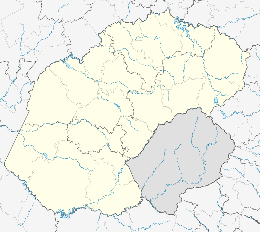
English: Location map of the Free State
Equirectangular projection, N/S stretching 114%. Geographic limits of the map:
|
| Letšatšikgwedi | |
| Mothopo |
|
| Mongwadi | Htonl |
| Permission (Reusing this file) |
I, the copyright holder of this work, hereby publish it under the following license: This file is licensed under the Creative Commons Attribution-Share Alike 3.0 Unported license.
|
| Other versions | File:South Africa Free State relief location map.svg, File:Blank map of the Free State (2011).svg |
.svg)
Histori ya faele
Pinyeletša go letšatšikgwedi/nako go bona faela ka tsela yeo ebego e le ka gona nakong yeo.
| LetšatšiKgwedi/Nako | Nkgogorupo-Nala | Bogolo | Mošomiši | Comment | |
|---|---|---|---|---|---|
| bjale | 01:54, 6 Pherekgong 2013 | | 1,130 × 1,008 (286 KB) | Htonl | == {{int:filedesc}} == {{Information |Description ={{en|Location map of the en:Free State Equirectangular projection, N/S stretching 114%. Geographic limits of the map: * N: 26.5° S * S: 31° S * W: 24.25° E * E: 30° E}} |Source = *... |
Tirišo ya Faele
More than 100 pages use this file. The following list shows the first 100 pages that use this file only. A full list is available.
- Arlington, Free State
- Bethany, Free State
- Bethlehem, Free State
- Bethulie
- Bloemfontein
- Boiketlo
- Boitekong
- Bolata
- Boshof
- Bothaville
- Botjhabelo
- Clarens, Free State
- Clocolan
- Cornelia, Free State
- Deneysville
- Dewetsdorp
- Edenburg
- Edenville, Free State
- Excelsior, Free State
- Fateng-Tse-Ntsho
- Fauresmith
- Ficksburg
- Fouriesburg
- Frankfort, Free State
- Gariep Dam (toropo)
- Harrismith
- Heilbron
- Hennenman
- Hobhouse, Free State
- Holly Country
- Jacobsdal
- Jagersfontein
- Kestell
- Kgotsong
- Kgubetswana
- Koffiefontein
- Koppies
- Kragbron
- Kroonstad
- Ladybrand
- Lindley, Free State
- Luckhoff
- Mabolela
- Makwane
- Marquard
- Matlakeng
- Memel, Free State
- Meqheleng
- Mofulatshepe
- Namahadi, Mafube
- Ntha
- Odendaalsrus
- Oppermansgronde
- Oranjeville
- Parys, Free State
- Paul Roux
- Petrus Steyn
- Petrusburg
- Petsana
- Philippolis
- Phuthaditjhaba
- Reddersburg
- Reitz, Free State
- Relebohile
- Roleleathunya
- Rooibult
- Rosendal, Free State
- Rouxville
- Sasolburg
- Saundershoogte
- Senekal
- Smithfield
- Springfontein
- Steynsrus
- Teisesville
- Thaba Phatswa
- Thembalihle
- Thibela
- Tlholong
- Trompsburg
- Tseki
- Tshiame
- Tweeling
- Tweespruit
- Uitkoms
- Van Stadensrus
- Ventersburg
- Verkykerskop
- Vierfontein
- Viljoensdrif
- Viljoenskroon
- Villiers, Free State
- Virginia, Free State
- Vrede, Free State
- Vredefort
- Warden, Free State
- Welkom
- Wepener
- Wesselsbron
- Zamani, Free State
View more links to this file.
Global file usage
The following other wikis use this file:
- Usage on af.wikipedia.org
- Bloemfontein
- Kroonstad
- Sasolburg
- Welkom
- Parys, Vrystaat
- Philippolis
- Bultfontein
- Trompsburg
- Rouxville
- Bethulie
- Bethlehem, Vrystaat
- Clarens, Vrystaat
- Fouriesburg
- Paul Roux
- Reitz
- Senekal
- Harrismith
- Kestell
- Lindley
- Wepener
- Golden Gate-Hoogland- Nasionale Park
- Clocolan
- Marquard
- Vrede, Vrystaat
- Memel, Vrystaat
- Arlington, Vrystaat
- Petrus Steyn
- Frankfort
- Villiers
- Cornelia
- Phuthaditjhaba
- Warden
- Ladybrand
- Ficksburg
- Rosendal
- Swinburne
- Tweeling, Vrystaat
- Zastron
- Excelsior, Vrystaat
- Hoopstad
- Sjabloon:Inligtingskas Nedersetting
- Jacobsdal
- Verkeerdevlei
- Winburg
- Botshabelo
- Vredefort
- Bothaville
- Jagersfontein
- Brandfort
- Koffiefontein
View more global usage of this file.