
Seswantšho:Port of Cape Town.jpg

Size of this preview: 800 × 461 pixels. Other resolutions: 320 × 184 pixels | 640 × 369 pixels | 1,024 × 590 pixels | 1,280 × 738 pixels | 2,560 × 1,476 pixels | 4,287 × 2,471 pixels.
''resolution'' ya gofella (4,287 × 2,471 pixel, bogolo ba faele: 8.22 MB, Mohuta wa MIME: image/jpeg)
Kakaretšo
| Description |
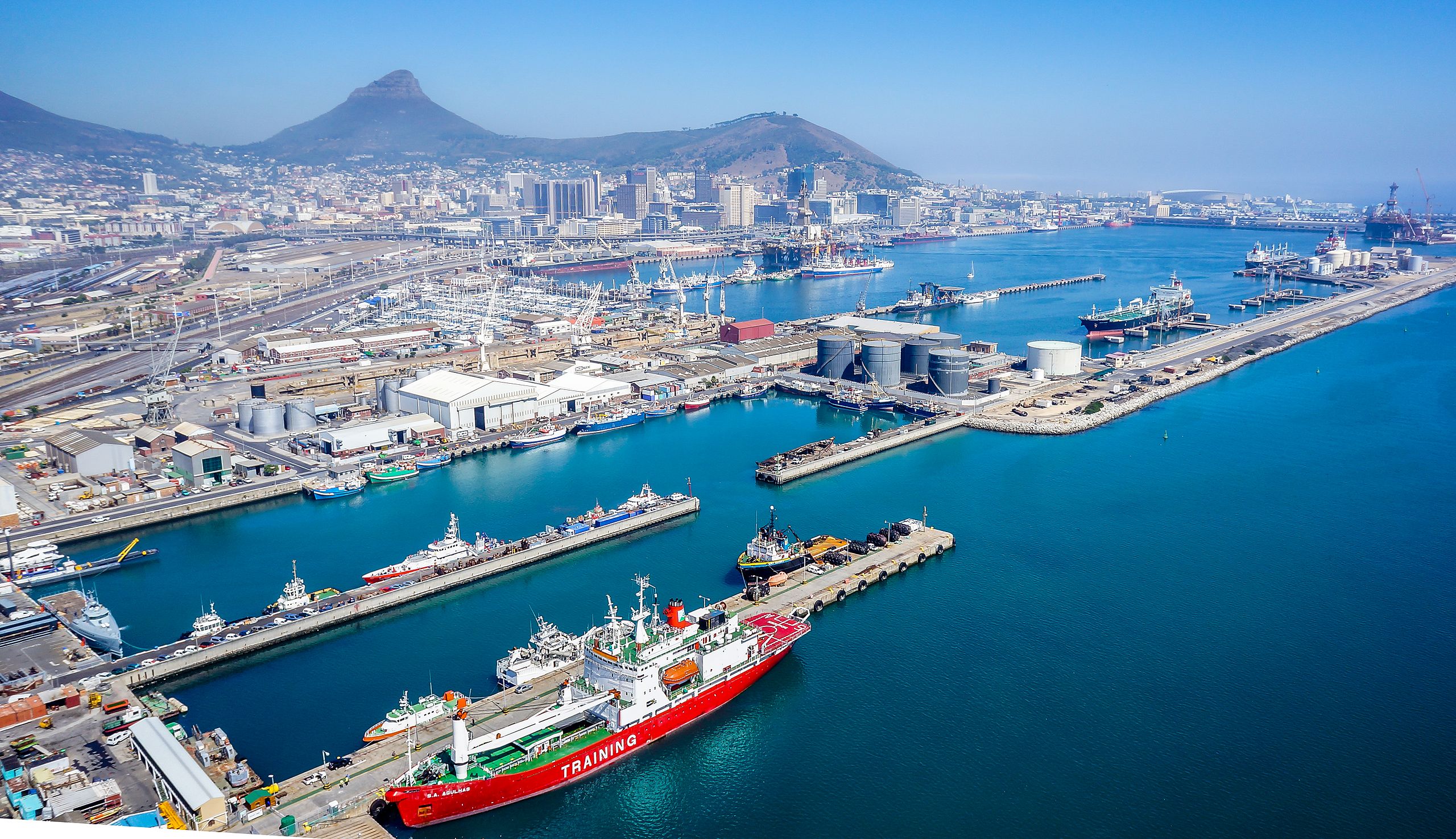
Afrikaans: Die hawe van Kaapstad bly 24 uur per dag en 7 dae per week oop. Die diepte van die toegangskanaal is -15.9m onder reduksievlak, -15.4m by die 180m breë ingang na Duncandok en -14m by die ingang na Ben Schoemandok. Die diepte in Duncandok wissel tussen -9.9m naby die herstelkaai tot -12.4m by die tenkerbekken. Ben Schoemandok wissel van -9m tot -13,9m. Die huidige (d.i. 2010) baggerwerk in Ben Schoemandok (houerterminaal) berei dieper meerplekke vir nuwe generasie-houerverskeping.
English: The port of Cape Town remains open 24 hours a day 7 days a week. The entrance channel's depth below chart datum is -15.9m, -15.4m at the 180m wide entrance into Duncan Dock and -14m at the entrance to Ben Schoeman Dock. The depth in the Duncan Dock varies between -9.9m near the repair quay to -12.4m at the tanker basin. Ben Schoeman Dock varies from -9m to -13.9m. Dredging is currently (i.e. 2010) underway in the Ben Schoeman Dock (container terminal) to provide deeper berths for new generation container shipping. |
| Letšatšikgwedi | |
| Mothopo | Own work |
| Mongwadi | SkyPixels |
| Camera location | | View this and other nearby images on: OpenStreetMap |
|---|
Laesense
I, the copyright holder of this work, hereby publish it under the following license:
This file is licensed under the Creative Commons Attribution-Share Alike 4.0 International license.
- You are free:
- to share – to copy, distribute and transmit the work
- to remix – to adapt the work
- Under the following conditions:
- attribution – You must give appropriate credit, provide a link to the license, and indicate if changes were made. You may do so in any reasonable manner, but not in any way that suggests the licensor endorses you or your use.
- share alike – If you remix, transform, or build upon the material, you must distribute your contributions under the same or compatible license as the original.
Histori ya faele
Pinyeletša go letšatšikgwedi/nako go bona faela ka tsela yeo ebego e le ka gona nakong yeo.
| LetšatšiKgwedi/Nako | Nkgogorupo-Nala | Bogolo | Mošomiši | Comment | |
|---|---|---|---|---|---|
| bjale | 19:40, 24 Mopitlo 2015 | | 4,287 × 2,471 (8.22 MB) | SkyPixels | User created page with UploadWizard |
Tirišo ya Faele
Letlakala le ke latelago a hlomaganya go faele ye:
Global file usage
The following other wikis use this file:
- Usage on af.wikipedia.org
- Usage on ang.wikipedia.org
- Usage on bn.wikipedia.org
- Usage on cs.wikipedia.org
- Usage on cy.wikipedia.org
- Usage on en.wikipedia.org
- Usage on fi.wikipedia.org
- Usage on he.wikipedia.org
- Usage on hy.wikipedia.org
- Usage on hyw.wikipedia.org
- Usage on ko.wikipedia.org
- Usage on ms.wikipedia.org
- Usage on ne.wikipedia.org
- Usage on pl.wikipedia.org
- Usage on ro.wikipedia.org
- Usage on ru.wikipedia.org
- Usage on sat.wikipedia.org
- Usage on smn.wikipedia.org
- Usage on sv.wikipedia.org
- Usage on th.wikipedia.org
- Usage on tr.wikipedia.org
- Usage on zh.wikipedia.org