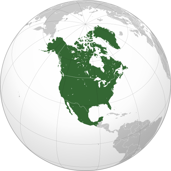
Seswantšho:North America (orthographic projection).svg
Page contents not supported in other languages.
Gotšwa go Wikipedia

''resolution'' ya gofella(SVG faele, nominally 550 × 550 pixels, bogolo ba faele: 457 KB)

Letlakala le letšwa Wikimedia Commons ebile le ka ba ke šumišwa ke di projeke tše dingwe.

Tlhaloso ya [letlakala https://commons.wikimedia.org/wiki/File:North_America_(orthographic_projection).svg tlhaloso ya faele] le laetšwa kago latela.

Kakaretšo

Description
বাংলা: ওত্তরী আমেরিকার অর্থোগ্রাফিক মানচিত্র
हिन्दी: उत्तरी अमेरिका का लेखनप्रक्षेपीय मानचित्र
English: North America (orthographic projection)
Letšatšikgwedi
Mothopo

Own work (Original text: Own work,)


বাংলা  English  español  français  italiano  日本語  македонски  sicilianu  中文(简体)  中文(繁體)  +/−

GNU head Permission is granted to copy, distribute and/or modify this document under the terms of the GNU Free Documentation License, Version 1.2 or any later version published by the Free Software Foundation; with no Invariant Sections, no Front-Cover Texts, and no Back-Cover Texts. A copy of the license is included in the section entitled GNU Free Documentation License.
Mongwadi Heraldry
Permission
(Reusing this file)
This image (or parts of it) was created by this user based on Adobe's Photoshop or Inkscape and probably converted to the portable network graphics format. It is (or includes) one of its different original designs, colours or styles from which you can choose.
You are free to share and make derivative works of the file under the conditions that you appropriately attribute it.
Other versions

Derivative works of this file:  BK North America (orthographic projection).png

This is a Grey & green orthographic projection map.
العربية: الرجاء، قراءة الميثاق.
বাংলা: দয়া করে, রীতিনীতিটি পড়ুন
Deutsch: Bitte lies die Konventionen.
English: Please, read the conventions.
Español: Por favor, lea las convenciones.
Filipino: Paki-basa ang mga kumbensyon.
Français : S'il vous plaît, lisez les conventions.
हिन्दी: कृपया सभागमों को पढ़ लें.
Bahasa Indonesia: Silakan, baca konvensi.
Italiano: Si prega di leggere le convenzioni.
ქართული: გთხოვთ, გაეცნოთ კონვენციებს.
Português: Por favor, leia as convenções.
Русский: Пожалуйста, прочитайте соглашения.
Українська: Будь ласка, прочитайте конвенції.
Tiếng Việt: Hãy đọc công văn trước khi đăng.
World maps

Africa

हिन्दी: अफ्रीका
ქართული: აფრიკა.

Eastern Africa

Southern Africa

Central Africa

Northern Africa

Western Africa

Americas

ქართული: ამერიკა.
हिन्दी: अमेरिका

North America

Central America

Caribbean

South America

Asia

ქართული: აზია.
Português: Ásia.
Українська: Азія.

East

Português: Ásia Oriental.
Українська: Східна Азія.

Central

हिन्दी: मध्य एशिया
Português: Ásia Central.
Українська: Центральна Азія.

Southeast

Bahasa Indonesia: Asia tenggara
Português: Sudeste Asiático.

South

(भारतीय उपमहाद्वीप)
Português: Sul da Ásia.
Українська: Південна Азія.

Western

Português: Sudoeste da Ásia.
Українська: Передня Азія.

Europe

हिन्दी: यूरोप
ქართული: ევროპა.
Português: Europa.
Română: Europa.
Русский: Европа.
Українська: Європа.

Countries

Oceania

हिन्दी: ओशिआनिया
ქართული: ოკეანეთი.
Português: Oceania.
Українська: Океанія.

Intercontinental

Português: Intercontinental.
Українська: Міжконтинентальні.

Historical

English: Unions, Organizations, Kingdoms, Empires
Español: Uniones, Organizaciones, Reinos, Imperios
Filipino: Mga Unyon, Organisasyon, Kaharian, Imperyo
Français : Unions, Organisations, Royaumes, Empires
हिन्दी: संघ, संगठन, राज्य, साम्राज्य व ऐतिहासिक देश
ქართული: გაერთიანებები, ორგანიზაციები, სამეფოები, იმპერიები
Português: Estados extintos.
Tagalog: Mga Unyon, Organisasyon, Kaharian, Imperyo
Українська: Союзи, Організації, Королівства, Імперії

Subnationals

हिन्दी: उपराष्ट्रीय इकाईयाँ

Orthographic projections maps created by Heraldry:

SVG genesis
InfoField
 
The source code of this SVG is invalid due to 99 errors.
 
This W3C-invalid world map was created with Inkscape…important.
 
SVG watermarked with invisible embedded text.

Laesense

I, the copyright holder of this work, hereby publish it under the following license:
GNU head Permission is granted to copy, distribute and/or modify this document under the terms of the GNU Free Documentation License, Version 1.2 or any later version published by the Free Software Foundation; with no Invariant Sections, no Front-Cover Texts, and no Back-Cover Texts. A copy of the license is included in the section entitled GNU Free Documentation License.
w:en:Creative Commons
attribution share alike
This file is licensed under the Creative Commons Attribution-Share Alike 3.0 Unported license.
You are free:
  • to share – to copy, distribute and transmit the work
  • to remix – to adapt the work
Under the following conditions:
  • attribution – You must give appropriate credit, provide a link to the license, and indicate if changes were made. You may do so in any reasonable manner, but not in any way that suggests the licensor endorses you or your use.
  • share alike – If you remix, transform, or build upon the material, you must distribute your contributions under the same or compatible license as the original.
This licensing tag was added to this file as part of the GFDL licensing update.

Captions

Add a one-line explanation of what this file represents

Items portrayed in this file

depicts English

copyrighted English

inception English

2010

MIME type English

image/svg+xml

Histori ya faele

Pinyeletša go letšatšikgwedi/nako go bona faela ka tsela yeo ebego e le ka gona nakong yeo.

LetšatšiKgwedi/NakoNkgogorupo-NalaBogoloMošomišiComment
bjale10:38, 27 Phupu 2023Nkgogorupo-Nala ya "version" go tloga 10:38, 27 Phupu 2023550 × 550 (457 KB)LasunnctyReverted to version as of 16:06, 17 January 2023 (UTC) duplicate
21:49, 25 Phupu 2023Nkgogorupo-Nala ya "version" go tloga 21:49, 25 Phupu 2023550 × 550 (455 KB)HelpfulHensCentral America and the Caribbean are all part of North America
18:06, 17 Pherekgong 2023Nkgogorupo-Nala ya "version" go tloga 18:06, 17 Pherekgong 2023550 × 550 (457 KB)Bultrothe map with all Mexico and Caribbean is file:Location North America.svg. We just also want THIS map. You may ask to rename it
00:28, 9 Pherekgong 2023Nkgogorupo-Nala ya "version" go tloga 00:28, 9 Pherekgong 2023550 × 550 (414 KB)HelpfulHensAdded Central America and the Caribbean
00:16, 9 Pherekgong 2023Nkgogorupo-Nala ya "version" go tloga 00:16, 9 Pherekgong 2023550 × 550 (457 KB)Bultrothe map without Mexico is File:Northern America (orthographic projection).svg
19:33, 7 Pherekgong 2023Nkgogorupo-Nala ya "version" go tloga 19:33, 7 Pherekgong 2023550 × 550 (676 KB)HelpfulHensRemoved Mexico
18:42, 7 Lewedi 2009Nkgogorupo-Nala ya "version" go tloga 18:42, 7 Lewedi 2009550 × 550 (457 KB)TownDownsized according
10:52, 10 Mosegamanye 2009Nkgogorupo-Nala ya "version" go tloga 10:52, 10 Mosegamanye 2009541 × 541 (457 KB)PuebloUniteddetails
10:23, 25 Phupu 2009Nkgogorupo-Nala ya "version" go tloga 10:23, 25 Phupu 2009541 × 541 (458 KB)TownDown{{Information |Description={{en|1=North America}} |Source=trabajo propio (own work) |Author=TownDown |Date= |Permission= |other_versions= }} <!--{{ImageUpload|full}}--> Category:Orthographic projections

Letlakala le ke latelago a hlomaganya go faele ye:

Global file usage

Metadata